
10-Day NOAA Snowfall Outlook Shows Heavy Western Mountain Totals and 3–6 Inches Across Northern Illinois and the Great Lakes
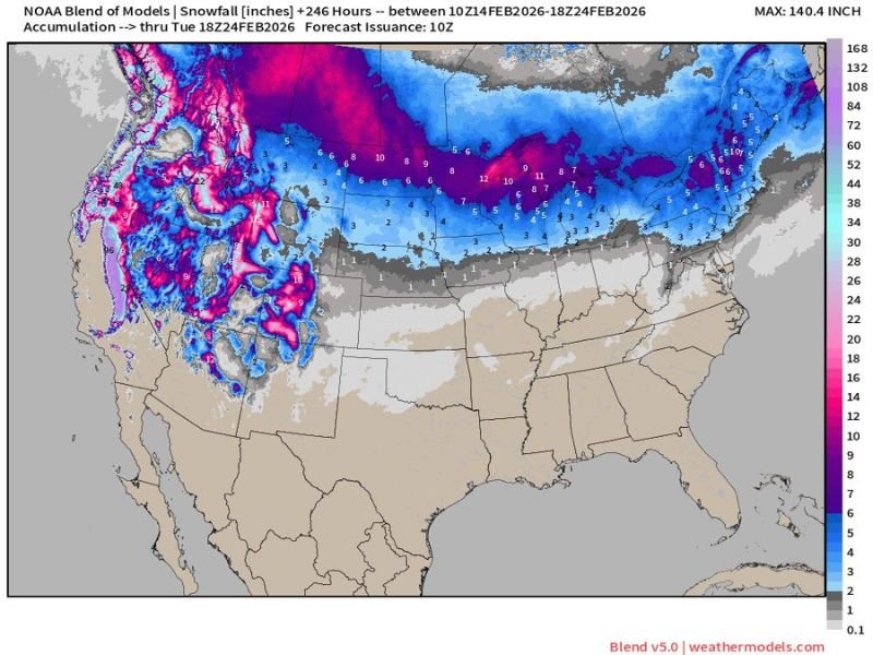
UNITED STATES — A new NOAA Blend of Models snowfall projection covering the next 10 days (through February 24, 2026) shows a very active winter pattern across the western U.S. and the northern tier, while the southern half of the country remains largely snow-free.
The long-range accumulation map highlights where winter weather is expected to concentrate between now and late next week — and northern Illinois is included in that zone.
Western U.S. Mountains Targeted for Major Snow
The most impressive totals on the map are centered over the western mountain ranges.
Deep pink and purple shading indicates very heavy snowfall across:
- The Washington and Oregon Cascades
- The Sierra Nevada in California
- The Idaho and Montana mountain ranges
- Portions of western Wyoming and Utah
- Higher terrain in Colorado
Some high-elevation areas show projected totals exceeding 2 to 4 feet, with isolated peaks pushing even higher amounts over the 10-day period. This type of pattern is typical when repeated Pacific storm systems move inland and track across the northern Rockies.
Northern Tier Stays Active From Montana to the Northeast
Beyond the mountains, a broader swath of steady but lighter snowfall stretches across the northern United States.
The map shows consistent accumulation potential across:
- Montana
- North Dakota
- Northern South Dakota
- Minnesota
- Northern Wisconsin
- Michigan
- Upstate New York
- Northern New England
Many of these areas fall within the 5 to 12 inch range over the 10-day window, depending on individual storm tracks. This suggests multiple systems rather than one single major blizzard.
Northern Illinois Included in Accumulation Zone
For the Chicago metro and Naperville area, the model blend places northern Illinois in a band of lighter but measurable snowfall.
Current projections indicate roughly:
- 3 to 6 inches possible across northern Illinois
- Slightly higher totals north of I-88 and toward the Wisconsin border
- Lower amounts trending south of central Illinois
While this is not signaling a blockbuster storm at this time, it does point to an active stretch with periodic snow chances rather than prolonged quiet weather. Because this is a 10-day blended outlook, totals would likely come from multiple systems spaced several days apart.
Southern U.S. Remains Largely Snow-Free
The map clearly shows minimal snowfall across:
- The Deep South
- The Gulf Coast
- Most of Texas
- The Southeast
- The Mid-Atlantic coastal plain
This reinforces a strong northern storm track keeping cold air locked across the upper tier of the country.
What This Means for Naperville
For residents in Naperville and across DuPage County, the key takeaway is:
- Winter is not finished.
- Snow chances continue into late February.
- No single extreme event is indicated right now.
- Totals appear manageable but steady.
As always with extended outlooks, storm tracks and temperatures can shift. Even a small deviation south or north could change local snowfall amounts significantly.
We’ll continue monitoring updated model runs to see if any single system within this 10-day window trends stronger for northern Illinois. Stay with NapervilleLocal.com for continued local weather updates as this active northern pattern unfolds.

I’ve lived in Naperville long enough to see how quickly our community changes — from new developments downtown to sudden shifts in our Midwest weather. Reporting on Naperville news and daily forecasts gives me the chance to keep neighbors informed about what really matters. My goal is simple: deliver clear, timely updates so you always know what’s happening in our city and what to expect from the skies above.