
11 AM to 7 PM Saturday: Line of Storms Targets Kentucky With Severe Risk Already Posted Across Region
KENTUCKY — Attention is shifting toward Saturday as a developing line of storms is expected to move across the state during the late morning through evening hours. While only a few showers are possible today, the focus is clearly on a more organized system arriving this weekend with an established severe weather risk.
Today Remains Quiet With Limited Showers
For today, conditions remain relatively calm across the region with only a few isolated showers possible.
Rain coverage is expected to stay minimal, allowing for a generally quiet day ahead of the more impactful weather expected on Saturday.
Saturday Storm Line Moves Through Midday to Evening
A line of storms is expected to move across Kentucky between 11:00 AM and 7:00 PM Saturday, marking the primary window for active weather.
This system is expected to be more organized compared to today’s isolated activity, bringing a higher potential for stronger storms.
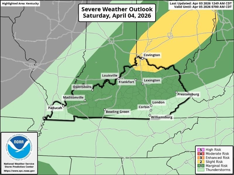
Severe Risk Already in Place Across the State
A severe weather outlook has already been issued, indicating that parts of Kentucky are under a risk for strong to severe storms.
The outlook shows:
- Marginal to slight risk across much of the state
- Higher risk focused toward northern and northeastern areas
Cities including Louisville, Lexington, Covington, Bowling Green, and surrounding regions fall within the broader risk zones.
Storms Could Strengthen as They Move Through
As the storm line progresses across the state, conditions may support periods of stronger storms during the afternoon and evening.
While exact storm intensity will depend on how the atmosphere evolves, the setup suggests potential for impactful weather during the peak window.
More Details Expected As System Approaches
Forecast details are expected to become clearer as the system gets closer, with additional updates likely later.
Residents are encouraged to stay alert and monitor forecast changes, especially heading into Saturday when the main weather impacts are expected. Stay with NapervilleLocal.com for the latest weather updates and local forecast coverage.

I’ve lived in Naperville long enough to see how quickly our community changes — from new developments downtown to sudden shifts in our Midwest weather. Reporting on Naperville news and daily forecasts gives me the chance to keep neighbors informed about what really matters. My goal is simple: deliver clear, timely updates so you always know what’s happening in our city and what to expect from the skies above.