
5 PM to 9 PM: Tornado Potential Targets Madison, St. Clair, Monroe, Randolph and Jackson County Areas Near Mississippi River
MISSISSIPPI RIVER CORRIDOR — A conditional severe weather setup is developing across areas west of I-57, with the greatest concern focused on counties along the Mississippi River. Current data suggests the best chance for isolated tornado development will occur during the evening hours, particularly in the listed county regions.
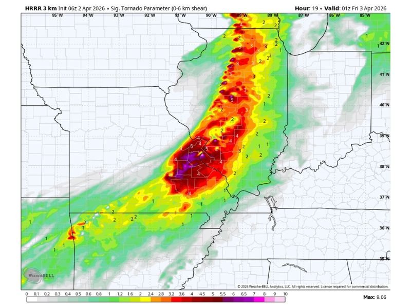
County Areas Near River See Highest Tornado Potential
The most favorable zone for potential tornado activity includes:
- Madison County
- St. Clair County
- Monroe County
- Randolph County
- Jackson County
These areas are expected to have the strongest combination of conditions needed for storm rotation later today.
Evening Window Between 5 PM and 9 PM
Storm development is trending toward the evening timeframe, with the primary window expected between 5:00 PM and 9:00 PM.
While exact timing may vary slightly, this period currently represents the most likely opportunity for stronger storms to form.
Model Signals Suggest Supercell Development
Forecast models indicate a corridor of stronger storm parameters developing around 8:00 PM, especially near the Mississippi River.
Simulated radar also shows the possibility of a well-organized supercell storm structure, which could support rotation if conditions align. However, this remains based on model guidance and is not a guaranteed outcome.
Uncertainty Remains in Storm Strength
This is not a guaranteed severe weather event. Several factors could influence storm development, including:
- Variability in timing
- Atmospheric instability levels
- Model differences in storm intensity
Most areas may not experience severe weather, but localized impacts could still occur where storms strengthen.
Monitoring Period Begins Late Afternoon
Storm monitoring is expected to increase during the 3 PM to 6 PM timeframe, as conditions evolve ahead of the evening risk window.
Residents in areas west of I-57 and near the Mississippi River, especially across the listed county regions, should stay alert for rapidly changing weather conditions. Stay with NapervilleLocal.com for the latest weather updates and local forecast coverage.

I’ve lived in Naperville long enough to see how quickly our community changes — from new developments downtown to sudden shifts in our Midwest weather. Reporting on Naperville news and daily forecasts gives me the chance to keep neighbors informed about what really matters. My goal is simple: deliver clear, timely updates so you always know what’s happening in our city and what to expect from the skies above.