
70s Set to Spread Across Much of the United States Feb. 11–17 as 8–14 Day Outlook Signals Major Warm-Up, With Some 80s Possible in the South
UNITED STATES — A national 8–14 day temperature outlook is pointing to a broad and noticeable warm-up across the country, with above-normal temperatures favored across much of the United States from February 11 through February 17. The forecast graphic shared with the provided data suggests that after a stretch of deep winter cold in many regions, springlike temperatures in the 70s could return to a large portion of the country, and some southern locations could flirt with the 80s.
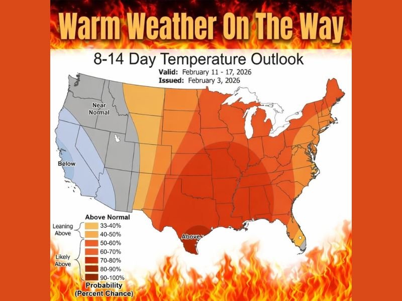
The outlook shown is an 8–14 Day Temperature Outlook with a validity window of Feb. 11–17, 2026, and it was issued Feb. 3, 2026. Most of the map is shaded in orange to deep red, indicating a strong signal for warmer-than-normal conditions for mid-February.
Where the warm-up is expected to be strongest
The highest probability shading for above-normal warmth covers a wide swath of the nation, including much of the central United States, the Midwest, the South, and parts of the East. The darker shading suggests the warm signal is not limited to one small corridor—it’s a broad-scale pattern shift that could be felt across multiple regions at the same time.
Even areas that typically stay locked into mid-winter chill in February may see a meaningful bump in temperatures if the pattern verifies, especially during the daytime.
What the map suggests for temperatures
The note paired with the graphic states that 70s are expected across a big chunk of the U.S. and that some 80s are possible in the South next week. That doesn’t mean every city hits those numbers, but it highlights the overall theme: a widespread thaw, with the warmest anomalies favored where the deeper reds appear.
For many places, this kind of warm-up can change day-to-day life quickly—reducing heating demand, melting leftover snowpack in colder regions, and accelerating early-season outdoor activity.
Not every region is in the warm zone
While most of the country is shaded warmer-than-normal, the graphic also shows areas in the far West leaning closer to near normal, with a small portion of the Southwest/West Coast region indicated as below normal. That contrast suggests the warm-up is expected to be most dominant east of the Rockies, while the far West may not feel the same level of mid-February “heat wave” relative to average.
What to watch during a mid-winter warm surge
A quick warm-up can bring side effects, especially in areas that recently dealt with snow and ice. Rapid melting, slush, and refreeze risks can appear if temperatures drop again afterward. The broader pattern can also set up sharper air-mass contrasts later in the month, which sometimes leads to more active storm tracks.
For now, the headline is simple: warm weather is on the way, and mid-February may feel more like early spring in many parts of the country.
Are you ready for a break from winter, or do you think the cold will come roaring back after this warm-up? Share your thoughts and keep following NapervilleLocal.com for daily weather pattern updates and what they mean for your week ahead.

I’ve lived in Naperville long enough to see how quickly our community changes — from new developments downtown to sudden shifts in our Midwest weather. Reporting on Naperville news and daily forecasts gives me the chance to keep neighbors informed about what really matters. My goal is simple: deliver clear, timely updates so you always know what’s happening in our city and what to expect from the skies above.