
9 PM to Midnight: Storm Line Weakens Toward Ohio With Limited Severe Risk and Isolated Wind Threat Near Indiana Border
OHIO — The latest morning update shows a shifting severe weather outlook, with conditions now trending less favorable for widespread severe storms during the late afternoon and early evening. However, attention turns to the late evening hours, when a line of storms is expected to move into the region, bringing a limited but notable risk—mainly across northwestern areas near the Indiana border.
Afternoon Conditions May Stay Quiet Due to Stable Atmosphere
A key factor in today’s forecast is the potential for a “capped” atmosphere, meaning a layer of stable air may prevent storms from developing during the late afternoon and early evening.
If this holds, much of the region could stay dry during this period, significantly lowering the earlier concerns for tornadoes and large hail. This setup would keep severe weather chances very low through early evening hours.
Late Evening Storm Line Arrives From the West
Storm activity is expected to increase later tonight, particularly between 9:00 PM and midnight, as a line of storms moves in from the west.
This line is expected to form ahead of stronger atmospheric dynamics but will begin to weaken as it approaches the region, especially near the Indiana-Ohio state line.
Strongest Storms Stay Northwest With Wind Risk
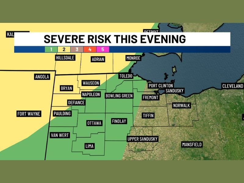
The greatest risk for stronger storms will remain focused in northwestern parts of the state, where a Level 2 severe risk is indicated.
Primary concerns include:
- Damaging wind gusts in stronger storms
- Reduced storm intensity as systems move east
- Transition from severe storms to general showers across central and eastern areas
As storms move east toward areas along and east of the I-75 corridor, they are expected to weaken into a band of rain showers with limited severe threat.
Eastern Areas Likely See Lower Impact
Communities further east are expected to experience little to no severe weather risk, with most activity weakening before arrival.
This creates a clear west-to-east gradient in impacts, with the strongest storms staying closer to the Indiana border and diminishing further east.
Overall Outlook Remains Conditional but Improved
While earlier forecasts suggested a higher severe weather potential, the updated outlook indicates a more limited and localized threat, largely dependent on how the atmosphere evolves through the day.
The situation still warrants attention, particularly in northwestern Ohio, but overall conditions appear less favorable for widespread severe weather than previously expected. Stay with NapervilleLocal.com for the latest weather updates and local forecast coverage.

I’ve lived in Naperville long enough to see how quickly our community changes — from new developments downtown to sudden shifts in our Midwest weather. Reporting on Naperville news and daily forecasts gives me the chance to keep neighbors informed about what really matters. My goal is simple: deliver clear, timely updates so you always know what’s happening in our city and what to expect from the skies above.