
Weather Models Hint at Possible Gulf Storm Development in Mid-November — Experts Urge Caution
ILLINOIS — As the Gulf Coast prepares to close out what has already been an active hurricane season, new weather model data suggests another possible tropical system may form in mid-November, potentially signaling an unseasonably late storm pattern.
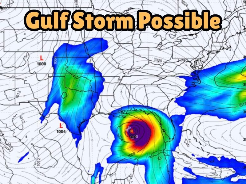
According to the Gulf Coast Severe Weather & Tropics forecasting page, the Global Forecast System (GFS) model has indicated a low-pressure system developing in the Gulf of Mexico around November 18, sparking speculation that the region could see one more storm before the season officially ends.
While this long-range projection has caught meteorologists’ attention, weather experts emphasize that the scenario remains highly uncertain and subject to change as the date approaches.
GFS Model Points to Gulf Development
The GFS model, a global forecasting system often used by meteorologists to identify early storm signals, currently shows a well-defined low-pressure system forming in the central Gulf before drifting toward the Southeast. The simulated pressure readings and moisture flow patterns resemble those of a tropical or subtropical system, though such model runs at this range can often overstate development.
“GFS has officially fallen off its rocker again,” forecasters from Gulf Coast Severe Weather joked in their report. “It’s showing a full-blown Gulf storm spinning up November 18 like it’s auditioning for ‘Hurricane Season: The Encore Tour.’”
The forecast image shared online depicts tight wind circulation over the northern Gulf and projected rainfall bands extending into parts of Alabama, Georgia, and the Florida Panhandle — areas that have already seen multiple systems this year.
Too Early for Certainty
Meteorologists caution against drawing firm conclusions from model projections that extend two weeks or more into the future. Long-range simulations like the GFS are known for “fantasy storms” that appear in early data but fail to materialize once refined models factor in updated temperature, wind, and sea surface conditions.
“Mother Nature might just be warming up for her dramatic entrance,” forecasters added humorously, reminding readers to “take a deep breath and remember it’s still two weeks away.”
Experts at the National Hurricane Center (NHC) have not yet issued any advisories or watches related to Gulf activity, though forecasters continue to monitor sea surface temperatures and atmospheric conditions across the Caribbean and southeastern U.S.
Late-Season Storms Not Unusual
While hurricane season officially ends on November 30, history has shown that late-season tropical systems are not uncommon. Warm Gulf waters and lingering jet stream interactions can occasionally trigger development even after the peak months of August and September.
Recent examples include Tropical Storm Eta (2020) and Hurricane Kate (2015) — both of which formed in November and impacted parts of the Gulf Coast and Atlantic seaboard.
What Residents Should Know
Meteorologists encourage residents across Gulf and southeastern states to remain weather-aware and ensure hurricane kits are not yet packed away. Even if the GFS projection doesn’t materialize, the potential underscores how unpredictable late-season weather can be.
For now, no immediate threat exists — but forecasters agree that the coming week will determine whether the system remains a curiosity or becomes the final named storm of 2025.
Stay updated with verified weather reports and forecast updates at NapervilleLocal.com.

I’ve lived in Naperville long enough to see how quickly our community changes — from new developments downtown to sudden shifts in our Midwest weather. Reporting on Naperville news and daily forecasts gives me the chance to keep neighbors informed about what really matters. My goal is simple: deliver clear, timely updates so you always know what’s happening in our city and what to expect from the skies above.