
South Dakota and Wyoming Under Winter Weather Advisory as 3–5 Inches of Snow Expected in the Black Hills
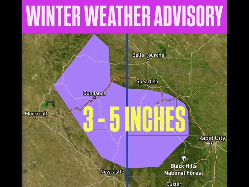
BLACK HILLS, SOUTH DAKOTA — A Winter Weather Advisory has been issued for parts of South Dakota and Wyoming, where up to 3–5 inches of snow are expected overnight through Saturday, according to meteorologist Chris Nunley and the National Weather Service.
The advisory covers communities across the Black Hills region, including Rapid City, Spearfish, Belle Fourche, Sundance, and Newcastle, where snowfall and reduced visibility could make travel hazardous overnight and early Saturday.
Heaviest Snowfall Expected Overnight
Forecasters say snow will begin late Friday evening, continuing through early Saturday morning with the heaviest accumulations expected at higher elevations in the Black Hills National Forest.
“Road conditions will deteriorate quickly as snow begins to accumulate,” Nunley warned. “Residents should be prepared for slick roads, slower commutes, and possible visibility issues.”
Localized areas could see totals above five inches, with snow gradually tapering off by midday Saturday.
Travel and Safety Concerns
Authorities are urging residents and travelers to plan ahead for difficult driving conditions. Snow-covered roads and patchy ice may develop overnight, particularly along Interstate 90 and mountain passes connecting South Dakota and Wyoming.
Officials recommend the following precautions:
- Allow extra travel time and reduce speed on snowy or icy roads.
- Keep headlights on and maintain a safe distance between vehicles.
- Carry an emergency kit including blankets, food, and water.
The South Dakota Department of Transportation and Wyoming Highway Patrol are monitoring road conditions and will issue updates as needed.
Forecast Outlook for the Weekend
While the snow is expected to ease by Saturday afternoon, cold temperatures will persist across the region, keeping conditions slick. Highs are forecast to remain in the upper 20s to low 30s, with another round of light snow possible early next week.
Meteorologists say the early November system marks one of the first significant snowfalls of the season for the Black Hills, signaling a quick shift into winter weather patterns for both states.
For continuing updates on regional weather alerts and travel conditions, visit NapervilleLocal.com for verified forecasts and public safety information.

I’ve lived in Naperville long enough to see how quickly our community changes — from new developments downtown to sudden shifts in our Midwest weather. Reporting on Naperville news and daily forecasts gives me the chance to keep neighbors informed about what really matters. My goal is simple: deliver clear, timely updates so you always know what’s happening in our city and what to expect from the skies above.