
Tennessee Severe Thunderstorm Warning Issued for Dayton, Spring City, and Pikeville Until 8:00 PM CST
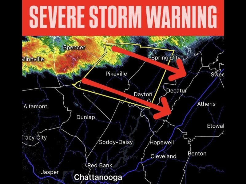
DAYTON, TENNESSEE — The National Weather Service has issued a Severe Thunderstorm Warning for parts of southeastern Tennessee, including the cities of Dayton, Spring City, and Pikeville, in effect until 8:00 PM CST.
Meteorologist Chris Nunley confirmed that radar detected strong storms moving through the region, bringing intense rainfall, frequent lightning, and the potential for damaging wind gusts and quarter-sized hail.
“A severe storm warning is now in effect for Dayton, Spring City, and Pikeville through 8 PM,” Nunley said. “Residents should stay indoors and remain weather aware as this system moves southeast.”
Storm Details and Expected Impacts
The storm system is tracking across Bledsoe, Rhea, and Meigs counties, moving southeast at approximately 40 miles per hour. Forecasters warn that wind gusts may exceed 60 miles per hour, which could result in downed trees, power outages, and hazardous travel conditions.
Communities within the warning area include:
- Dayton
- Spring City
- Pikeville
- Decatur
- Spencer
The leading edge of the storm has already produced significant lightning and heavy downpours north of Chattanooga, with the potential for hail and localized flash flooding in low-lying areas.
Safety Recommendations
Residents in the affected counties are urged to take immediate precautions:
- Seek shelter indoors and avoid windows.
- Move to an interior room on the lowest floor of your home.
- Avoid driving until the storm has passed.
- Keep phones charged and stay tuned to NOAA Weather Radio or trusted local stations for updates.
If outdoors, find a sturdy shelter immediately, as lightning and flying debris can pose life-threatening hazards.
Regional Weather Outlook
Forecasters say this severe cell is part of a larger system sweeping through southern Tennessee this evening, with the potential for additional storm development in nearby areas, including Cleveland, Soddy-Daisy, and Jasper. Conditions are expected to gradually improve later tonight as the system moves eastward.
Meteorologists advise residents across eastern Tennessee to remain alert throughout the evening, as isolated severe storms may continue until midnight.
For ongoing severe weather alerts, radar updates, and safety information, visit NapervilleLocal.com for the latest verified forecasts.

I’ve lived in Naperville long enough to see how quickly our community changes — from new developments downtown to sudden shifts in our Midwest weather. Reporting on Naperville news and daily forecasts gives me the chance to keep neighbors informed about what really matters. My goal is simple: deliver clear, timely updates so you always know what’s happening in our city and what to expect from the skies above.