
Tennessee Valley Braces for Severe Weather Threat Including Tornadoes, Damaging Winds, and Large Hail
NASHVILLE, TENNESSEE — Meteorologists are warning residents across the Tennessee Valley to remain alert this afternoon as forecasters monitor the potential for severe thunderstorms, including tornadoes, damaging winds, and large hail.
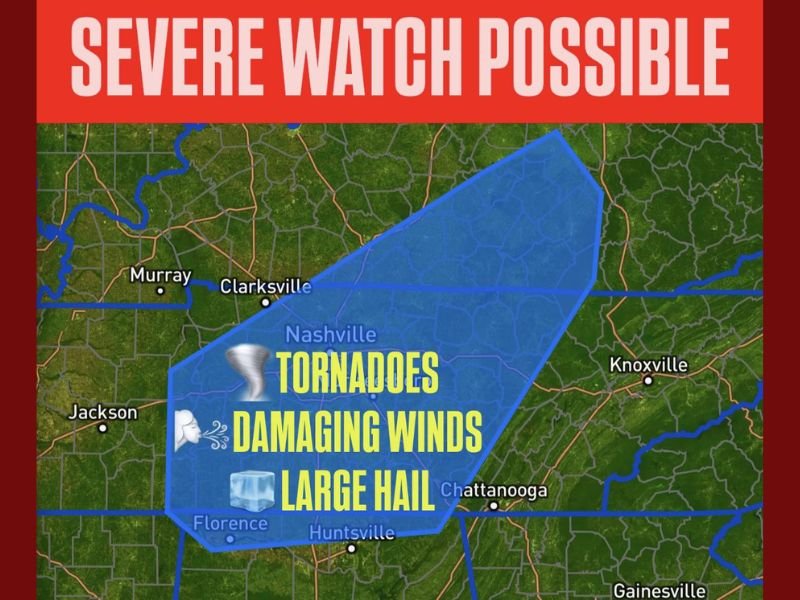
According to Meteorologist Chris Nunley, a severe weather watch may be issued later today as atmospheric conditions become increasingly favorable for the development of intense storms across central and southern Tennessee, including Nashville, Clarksville, Chattanooga, and Florence.
“A severe watch may be needed this afternoon for the Tennessee Valley,” Nunley said. “The Storm Prediction Center is monitoring this potential, with all modes of severe weather possible.”
Areas Under Threat
The region most at risk includes parts of Middle and Southern Tennessee, extending from Clarksville and Nashville south toward Huntsville, Alabama, and east toward Chattanooga.
Meteorologists say storms could intensify rapidly as warm, moist air interacts with a strong cold front moving in from the west. This combination could lead to rotating thunderstorms, increasing the potential for tornado formation.
In addition to tornado risks, forecasters warn of:
- Wind gusts exceeding 60 mph capable of downing trees and power lines
- Hail up to one inch or larger in diameter
- Heavy rainfall that may cause localized flooding in low-lying areas
Timing and Preparedness
The most active window for severe storms is expected between 3:00 p.m. and 9:00 p.m. CST, though conditions could vary depending on storm development.
Residents are urged to:
- Keep a NOAA Weather Radio or smartphone alerts enabled.
- Identify a safe shelter area, such as a basement or an interior room away from windows.
- Avoid outdoor activities during the watch period.
- Have an emergency kit ready with essentials in case of power outages.
“All it takes is one storm to cause major impacts,” Nunley added. “Even if a tornado doesn’t form, damaging winds and hail can still create dangerous conditions.”
Power and Travel Concerns
Utility companies across the Tennessee Valley are preparing for potential power outages, while emergency management agencies have advised residents to avoid unnecessary travel during active warnings.
Drivers are reminded never to attempt to drive through flooded roadways and to pull over if visibility drops due to heavy rain or hail.
Ongoing Monitoring
The Storm Prediction Center (SPC) continues to assess the evolving storm setup. If conditions worsen, a Severe Thunderstorm Watch or Tornado Watch could be issued for multiple Tennessee counties.
Meteorologists emphasize that residents should not wait for official warnings before taking precautions, as rapid storm development is possible throughout the evening.
For live weather updates, radar coverage, and safety alerts across the Tennessee Valley, follow NapervilleLocal.com for verified reports and ongoing coverage.

I’ve lived in Naperville long enough to see how quickly our community changes — from new developments downtown to sudden shifts in our Midwest weather. Reporting on Naperville news and daily forecasts gives me the chance to keep neighbors informed about what really matters. My goal is simple: deliver clear, timely updates so you always know what’s happening in our city and what to expect from the skies above.