
Tornado Watch in Effect Until 10 PM for Northern Alabama and Middle Tennessee as Storms Move Through
HUNTSVILLE, ALABAMA — A Tornado Watch remains in effect until 10 PM Friday for far northern Alabama counties and all of Middle Tennessee, as a line of strong to severe thunderstorms moves through the region this evening.
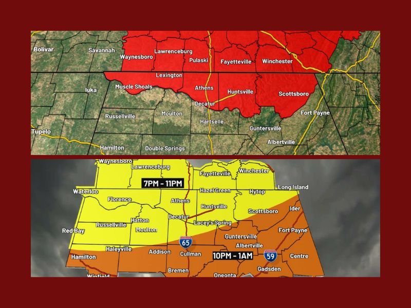
According to WAFF 48 First Alert Weather, the storms are expected to enter northwest Alabama and areas along the Tennessee state line between 7 and 8 PM, bringing threats of damaging winds, hail, and possible tornadoes.
Strong Storms Developing Across the Tennessee Valley
Meteorologists say the most significant impact will likely come from isolated damaging straight-line winds, though wind shear and instability are creating conditions capable of producing tornadoes.
“We’re watching for possible tornado development tonight as storms move east of the Tennessee River,” forecasters warned. “Frequent lightning and dime-sized hail will also be possible in addition to heavy rain.”
Residents across Huntsville, Decatur, Florence, Athens, and Scottsboro are being urged to stay weather-aware and have multiple ways to receive alerts, including weather radios and mobile apps.
Forecast Timeline and Safety Recommendations
Forecasters expect storms to move into the Tennessee Valley between 7 PM and 11 PM, with isolated severe weather lingering until around midnight. The severe threat is expected to diminish after midnight, moving eastward out of the region.
Saturday is forecasted to bring quiet weather with partial sunshine and highs in the lower 70s, offering a brief break before a strong arctic cold front arrives late Saturday night.
Arctic Front to Bring Big Drop in Temperatures
Meteorologists warn that an arctic front will push through the region on Sunday, dropping afternoon highs into the 40s with wind chills in the 30s. Overnight lows early Monday could plunge into the 20s, leading to a hard freeze across much of northern Alabama and southern Tennessee.
By Monday afternoon, temperatures are expected to stay near 50°F, with a gradual warm-up by midweek, returning to the 60s by Wednesday.
“This weekend will be a transition from mild to winter-like conditions,” forecasters added. “Residents should prepare for freezing temperatures and gusty north winds early next week.”
Stay Informed
Authorities are reminding residents to keep a close watch on weather alerts throughout the evening and to avoid unnecessary travel during severe storms.
For continuous updates on tonight’s storm activity and upcoming cold-weather alerts, follow NapervilleLocal.com for verified weather information and safety advisories.

I’ve lived in Naperville long enough to see how quickly our community changes — from new developments downtown to sudden shifts in our Midwest weather. Reporting on Naperville news and daily forecasts gives me the chance to keep neighbors informed about what really matters. My goal is simple: deliver clear, timely updates so you always know what’s happening in our city and what to expect from the skies above.