
Snow Flurries Possible Across North and Central Alabama as Arctic Air Moves In Monday
BIRMINGHAM, ALABAMA — Residents across North and Central Alabama are bracing for an unusually cold start to the week as forecasters say temperatures could drop near or below freezing Monday, with a chance of spotty snow flurries in some areas.
Cold Front Brings Freezing Air and Light Snow Chances
Meteorologists including Jordan West and Jason Simpson say the cold front sweeping through the region Sunday night will leave behind enough wrap-around moisture to produce brief snow showers across northeast Alabama, especially around Fort Payne, Gadsden, and Anniston.
“There will be enough wrap-around moisture for some spotty snow flurries across northeast Alabama,” said meteorologist Jordan West, adding that models show temperatures dropping to near freezing by early Monday morning.
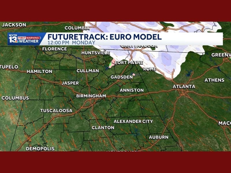
Forecast models — including the HRRR and EURO models — both indicate the possibility of light winter precipitation, though forecasters emphasize the impact should be minimal. The HRRR suggests flurries or cold rain as far south as Birmingham, while the EURO model limits snow activity to the northern tier near the Tennessee line.
Forecasters Urge Caution, But No Major Impacts Expected
While the snow chances have drawn attention, experts stress this will be more of a novel event than a hazardous one. Roads are expected to remain dry, and no travel disruptions are anticipated.
“It’s not a big deal,” said meteorologist Jason Simpson. “But if I saw one snowflake, I’d still be just as impressed as I always am. Little or big, it’s fun.”
Even with little accumulation expected, residents should bundle up, as wind chills could make it feel even colder, especially across higher elevations in northeast Alabama.
Freezing Temperatures Likely Statewide
Across the broader region, temperatures will fall into the upper 20s and low 30s Monday morning, marking one of the coldest starts to November so far. Freeze warnings remain possible for parts of northern Alabama and adjoining Tennessee counties.
The cold pattern is expected to last into early Tuesday before temperatures slowly rebound midweek.
Stay tuned to NapervilleLocal.com for continuous updates on winter weather developments and local forecasts.

I’ve lived in Naperville long enough to see how quickly our community changes — from new developments downtown to sudden shifts in our Midwest weather. Reporting on Naperville news and daily forecasts gives me the chance to keep neighbors informed about what really matters. My goal is simple: deliver clear, timely updates so you always know what’s happening in our city and what to expect from the skies above.