
Sudden Stratospheric Warming Event Could Trigger Deep South Winter Blast, Bringing Cold and Snow Farther South
ILLINOIS — Meteorologists are warning that a major Sudden Stratospheric Warming (SSW) event may send a wave of Arctic air plunging deep into the United States, setting the stage for an early winter pattern that could stretch as far south as Mississippi, Alabama, and Georgia — and bring significant cold and snow to the Midwest, including Illinois.
The SSW event, a dramatic disturbance in the upper atmosphere, has effectively “kicked the Polar Vortex in the shins,” according to forecasters, causing the jet stream to buckle and allowing Arctic air to spill far south of its usual position.
Arctic Air Could Reach the Deep South
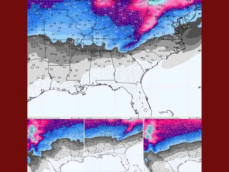
New weather model projections show a broad band of frigid air and snow potential expanding southward through the central and eastern U.S., including Illinois, Indiana, Ohio, and Kentucky, with lighter accumulations possible across parts of the Deep South.
The latest forecast maps reveal that snow totals could exceed 6 inches in northern Illinois and the Great Lakes region, while areas as far south as Tennessee and northern Alabama could experience their first measurable snow of the season if the pattern continues to trend colder.
“The snow line keeps sliding south like it’s avoiding rent payments,” joked one forecaster from Gulf Coast Severe Weather & Tropics. “If this pattern verifies, we could be talking about a Deep South winter slap right around the holidays.”
What Sudden Stratospheric Warming Means
A Sudden Stratospheric Warming event occurs when temperatures in the stratosphere rise sharply, disrupting the Polar Vortex — the cold air mass that typically circulates around the Arctic. When this vortex weakens or splits, cold air can surge southward into the continental U.S., often leading to major cold outbreaks and snow events.
Meteorologists say that this particular SSW could result in a prolonged cold spell across much of the eastern half of the country, starting late November and possibly extending into early December.
Illinois and Midwest Could See Early Winter Conditions
For Illinois residents, the incoming pattern could mean below-normal temperatures and an increased risk of snowfall, particularly in northern and central parts of the state. Cities like Chicago, Naperville, and Rockford may experience an early taste of winter, while southern Illinois could see frosty mornings and freezing rain potential.
Forecasters note that while long-range models can shift, the trend toward colder and stormier conditions has remained consistent for several days — a sign that the early-winter setup may hold.
Tips for Residents as Winter Approaches
Meteorologists are advising residents across the Midwest and South to prepare now in case the pattern verifies:
- Check heating systems and space heaters to ensure they are functioning safely.
- Locate winter gear, including gloves, coats, and boots that may be tucked away since last season.
- Prepare outdoor pets and livestock for a sharp temperature drop.
- Stay updated with local weather alerts for potential snow or ice events.
“If this keeps trending,” forecasters said humorously, “it’s going to be Frozen 3: Bless Your Cold Southern Hearts Edition.”
With temperatures expected to plummet and possible snow reaching unusually far south, residents across Illinois and beyond should brace for a dramatic shift from fall warmth to a full-on Arctic blast just as the holiday season approaches.
Stay with NapervilleLocal.com for the latest updates on Illinois and Midwest winter weather forecasts.

I’ve lived in Naperville long enough to see how quickly our community changes — from new developments downtown to sudden shifts in our Midwest weather. Reporting on Naperville news and daily forecasts gives me the chance to keep neighbors informed about what really matters. My goal is simple: deliver clear, timely updates so you always know what’s happening in our city and what to expect from the skies above.