
Severe Weather Threat Expected Across Texas, Louisiana, Mississippi, and Alabama Before Arctic Cold Front Hits Next Week
UNITED STATES — Meteorologists are warning that a volatile weather pattern could develop next week across the Deep South, bringing strong storms and potential tornadoes before a powerful Arctic cold front locks into much of the country.
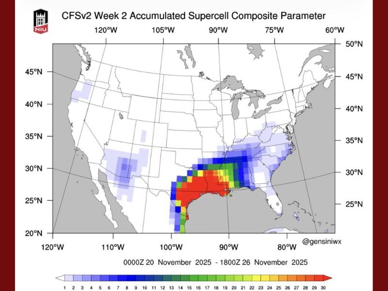
According to new long-range weather models, the upcoming system could deliver severe thunderstorms from Texas through Louisiana, Mississippi, and Alabama, marking one of the most dynamic November setups of the season so far.
Storm System Could Pack a Punch Before Cold Air Moves In
Data from the CFSv2 model, shared by the Gulf Coast Severe Weather & Tropics group, shows a surge in atmospheric instability — described by experts as the “spiciness” or energy potential of the air mass — stretching from eastern Texas into the lower Mississippi Valley.
This pattern often indicates the potential for supercell thunderstorms, capable of producing damaging winds, hail, and tornadoes.
“This isn’t your average fall storm setup,” meteorologists explained. “Before the cold air rushes in, the South could be looking at a strong line of storms that bring both wind damage and isolated tornado threats.”
Forecast: Severe Weather First, Arctic Blast After
Forecasters believe the sequence will unfold in two distinct phases:
- Early Week (Severe Threat):
- Thunderstorms expected to organize from Texas into Alabama.
- Risk for rotating storms and short-lived tornadoes possible in the warm, humid air mass.
- Heavy rain may lead to localized flooding in low-lying areas.
- Mid-to-Late Week (Arctic Air Intrusion):
- A sharp cold front will surge southward, dropping temperatures by 20–40 degrees in less than 48 hours.
- The sudden shift could lead to rapid cooling and icy conditions in northern regions.
“Cold air never sneaks in quietly,” one forecast discussion noted. “It tends to kick the door open — and that’s exactly what next week’s pattern looks like.”
Southern States at Greatest Risk
The highest potential for severe storms currently extends across eastern Texas, Louisiana, Mississippi, and southern Alabama, though surrounding regions could see impacts as well.
Meteorologists caution that this setup is still evolving but say that signals for strong atmospheric rotation are unusually bold for mid-November.
Residents across the Deep South are urged to stay alert for updated forecasts and have emergency weather plans ready.
Why It’s Happening
This clash of extremes — severe storms followed by an Arctic plunge — is being fueled by strong temperature contrasts between lingering Gulf warmth and the advancing northern cold front.
As the polar air mass builds, it’s expected to dominate much of the country by Thanksgiving week, locking in winter-like conditions for the Midwest, Ohio Valley, and parts of the East Coast.
What to Expect Next
Forecasters are emphasizing that this outlook is still developing, but if trends hold, parts of the Deep South could face one of their more active November storm systems in recent years.
Residents are encouraged to prepare for:
- Strong winds over 50 mph in severe cells
- Potential tornado watches and warnings
- Possible travel disruptions as storms transition into freezing air
Meteorologists expect clearer details in the coming days as newer model runs refine the timing and strength of the approaching front.
For continued weather coverage and regional impact updates, stay tuned to NapervilleLocal.com.

I’ve lived in Naperville long enough to see how quickly our community changes — from new developments downtown to sudden shifts in our Midwest weather. Reporting on Naperville news and daily forecasts gives me the chance to keep neighbors informed about what really matters. My goal is simple: deliver clear, timely updates so you always know what’s happening in our city and what to expect from the skies above.