
Washington and Oregon Brace for Coldest Thanksgiving Week as Snow Levels Drop to Valley Floors
SEATTLE, Washington — A surge of Arctic air is expected to sweep across the Pacific Northwest and Inland Northwest leading into Thanksgiving week, bringing the coldest temperatures of the season and the potential for low-elevation snowfall in Washington, Oregon, Idaho, and western Montana. Meteorologists say this setup could create hazardous travel conditions as snow levels plunge toward valley floors and mountain passes.
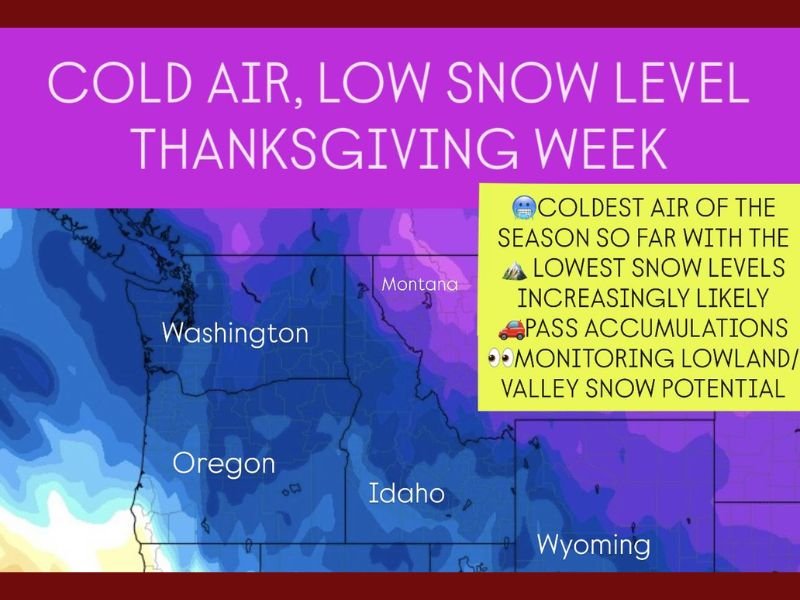
According to the National Weather Service (NWS), a strong cold front will dive south from British Columbia and the northern Rockies early in the week, sending temperatures well below normal and producing the lowest snow levels of the season so far. The cold air mass will establish itself across the Pacific Northwest before spreading into the central and eastern U.S. by Thanksgiving weekend.
“We’re looking at a significant early-season cold spell,” meteorologists said. “Snow levels could drop below 1,500 feet in some areas, which means we might see flakes flying in valleys and lower elevations that rarely experience November snow.”
Coldest Air of the Season Taking Hold
Temperatures are forecast to tumble 15–25 degrees below average across the region, with overnight lows dipping into the teens and single digits in higher terrain. The chill will extend across Washington, Oregon, Idaho, Wyoming, and western Montana, marking one of the earliest and most widespread cold outbreaks of the fall.
Daytime highs may struggle to rise above freezing in the Cascades and interior valleys. Forecasters say the pattern could last several days, keeping mountain passes icy and potentially affecting holiday travel.
Snow Levels Expected to Plummet Across the Region
As the Arctic air pushes in, snow levels are projected to drop rapidly. Forecasters expect snow to reach elevations as low as 1,000 to 2,000 feet in western Washington and Oregon and possibly lower across eastern Washington and northern Idaho. Mountain passes including Snoqualmie, Stevens, and Lookout Pass could see several inches of snow accumulation, creating slick conditions for travelers.
Higher elevations could see 4–10 inches of snow, while interior valleys might experience a wintry mix or light snow showers depending on moisture availability. The NWS cautions that even minor accumulations could make roads treacherous for drivers heading into Thanksgiving week.
“Cold air combined with lingering moisture is the perfect setup for surprise lowland snow,” the NWS in Spokane said. “It’s not guaranteed yet, but confidence is increasing for at least light accumulations.”
Potential Travel Impacts for Thanksgiving Week
The timing of this cold snap raises concerns for Thanksgiving travel plans, particularly for those driving through mountain corridors or rural routes in eastern Washington, Idaho, and Oregon’s Cascade foothills. If snow reaches valley floors, it could lead to slippery conditions and localized disruptions across interstates like I-90, I-84, and I-82.
Airports in Seattle, Portland, and Boise are also on alert for potential delays if snow showers develop near runways or approach paths during the week. Forecasters recommend travelers monitor conditions closely and prepare for rapidly changing weather.
Colder Air Expanding East After Thanksgiving
The cold pattern in the Pacific Northwest will act as the launching point for a broader Arctic blast expected to move into the central and eastern United States later in the week. This same system could merge with a developing low-pressure area to create widespread winter weather extending into the Midwest and Great Lakes by the weekend.
“This cold outbreak is setting the stage for what could become a cross-country pattern shift,” forecasters added. “By the holiday weekend, even areas east of the Mississippi could be feeling the chill.”
What to Expect in the Coming Days
- Sunday–Monday: Cold front moves into the Pacific Northwest; rain transitions to snow at higher elevations.
- Tuesday–Wednesday: Arctic air deepens, dropping snow levels to valleys and foothills.
- Thanksgiving Day: Frigid morning lows, potential lingering snow showers in interior valleys and passes.
- Weekend: Cold air pushes east, spreading below-average temperatures across the Plains and Midwest.
Preparation Tips for Residents and Travelers
- Check local forecasts frequently as snow potential becomes clearer.
- Prepare vehicles for winter driving with chains, de-icer, and emergency kits.
- Dress in layers and protect outdoor pipes and pets from subfreezing temperatures.
- If traveling through mountain passes, allow extra time and consider alternate routes.
Forecasters say the next 48 hours will be key in determining whether snow reaches lower elevations, but confidence is growing that the Pacific Northwest will face its first major cold blast of the season just as millions begin their Thanksgiving travel plans.
Stay connected to NapervilleLocal.com for continued updates on national weather developments affecting Thanksgiving week travel.

I’ve lived in Naperville long enough to see how quickly our community changes — from new developments downtown to sudden shifts in our Midwest weather. Reporting on Naperville news and daily forecasts gives me the chance to keep neighbors informed about what really matters. My goal is simple: deliver clear, timely updates so you always know what’s happening in our city and what to expect from the skies above.