
Above-Normal Rainfall Expected Across Much of the U.S. as Thanksgiving Week Approaches, With Texas at the Highest Risk
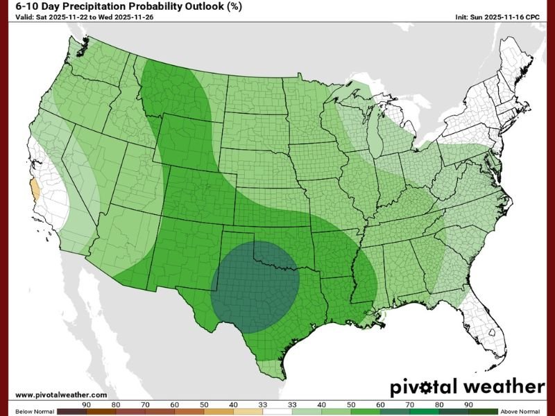
UNITED STATES — A new national outlook from the Climate Prediction Center shows that much of the United States is expected to see above-normal rainfall in the days leading up to Thanksgiving (Nov. 22–Nov. 26), with the highest precipitation risk centered over Texas and the Southern Plains. Forecasters say multiple rounds of heavy rain and thunderstorms could begin as early as Thursday, with additional updates expected as the holiday approaches. The probability map shows a widespread green shading across the Midwest, Great Lakes, and central U.S., signaling wetter-than-average conditions for millions of travelers.
What the New Forecast Shows for Thanksgiving Week
According to the 6–10 Day Precipitation Probability Outlook, the strongest anomaly on the map is a dark green/high-risk zone directly over Texas, extending into Oklahoma, Arkansas, and parts of Louisiana. This region shows the highest chance of above-average precipitation during the Nov. 22–26 period. Lighter green zones spread across Illinois, Indiana, Wisconsin, Ohio, and the entire Midwest, indicating elevated rain potential for travelers heading out before Thanksgiving.
Meteorologists say the pattern suggests a series of active storm systems sweeping across the central and southern United States. This could mean steady rainfall, thunderstorms, and possible travel delays, particularly for those in regions where the probability reaches 60–70% above seasonal norms.
For Illinois and the Chicago suburbs, forecasters expect increased rain chances, cloudier skies, and a shift toward a wetter-than-average holiday week, though exact rainfall totals will be refined in upcoming updates.
Why Texas Is at the Center of the Highest Rainfall Probability
The shaded precipitation bullseye on the map shows Texas as the focal point of the upcoming pattern. Meteorologists say the state sits beneath the strongest atmospheric moisture feed, where incoming storm systems are likely to slow down, intensify, or repeatedly form. This increases the likelihood of:
- Heavy downpours
- Thunderstorms
- Localized flooding
- Disrupted travel conditions
Forecasters note that the moisture pipeline from the Gulf of Mexico typically strengthens during late November, and this year appears to follow that trend. With models consistently highlighting Texas in the highest risk zone, the state may see some of the greatest rainfall totals nationwide during the days leading up to Thanksgiving.
What This Mean for Holiday Travel Across the Country
With millions of people preparing for Thanksgiving travel, the forecast serves as a significant early alert. The combination of storms, dense cloud cover, and wetter-than-normal conditions could bring:
- Airport delays across central and southern states
- Slower highway travel due to rain and low visibility
- Potential flooding issues in parts of Texas and Oklahoma
- Heavier traffic congestion as drivers navigate wet roads
Travelers in the Midwest—including Illinois, Indiana, and Wisconsin—should prepare for periodic rain, wet pavement, and expanded travel times, though severe conditions appear more concentrated further south.
Meteorologists say more refined rainfall predictions and timing-specific updates will be released over the next 24–48 hours as new model data arrives.
If you want continued updates on major weather developments, holiday travel conditions, and regional forecasts, stay connected with NapervilleLocal.com for the latest reports.

I’ve lived in Naperville long enough to see how quickly our community changes — from new developments downtown to sudden shifts in our Midwest weather. Reporting on Naperville news and daily forecasts gives me the chance to keep neighbors informed about what really matters. My goal is simple: deliver clear, timely updates so you always know what’s happening in our city and what to expect from the skies above.