
Heavy Rain, Thunderstorms, and 2–4 Inches of Accumulation Expected Across Texas From Wednesday Through Sunday, Forecasters Warn
TEXAS — A series of strong storm systems is expected to sweep across Texas beginning Wednesday afternoon and lasting through Sunday night, bringing heavy rainfall, frequent lightning, gusty winds, and a low but notable tornado risk, according to early mid-week projections. Weather experts say the atmosphere will be fully saturated, creating ideal conditions for efficient storms capable of producing 2-inch-per-hour rainfall rates. Forecast models show 2 to 4 inches of total accumulation across much of the state.
What Forecasters Say Texans Should Prepare For
Meteorologists describe Texas as experiencing a “feast-or-famine” pattern this season, going three weeks without rain in October, followed by multiple heavy rainfall events, and then another three-week dry stretch in November—now ending with yet another significant storm setup.
Early projections highlight several weather hazards expected between Wednesday and Sunday, including:
- Gusty winds
- Frequent lightning
- Heavy rainfall with 2” per hour rates
- Small hail possible
- Low-end tornado risk (not zero)
- Likely Flood Warnings, especially where storms repeatedly pass over the same areas
Forecasters emphasize that any storm forming in this environment will be highly efficient, meaning rainfall rates could climb quickly and flash flooding could develop, especially in urban regions and low-lying locations.
Why the Heavy Rain Setup Is So Strong This Week
Meteorologists report that the atmosphere will be fully saturated, meaning moisture levels are unusually high from the surface to the upper levels of the atmosphere. This saturation increases the likelihood of:
- High-volume rainfall
- Long-duration thunderstorms
- Storm “training,” where multiple cells pass repeatedly over the same region
- Short-notice flood advisories and warnings
Friday may bring a temporary break in rainfall intensity, but early models show additional rounds of rain returning on Saturday night into Sunday, keeping the risk elevated through the entire weekend.
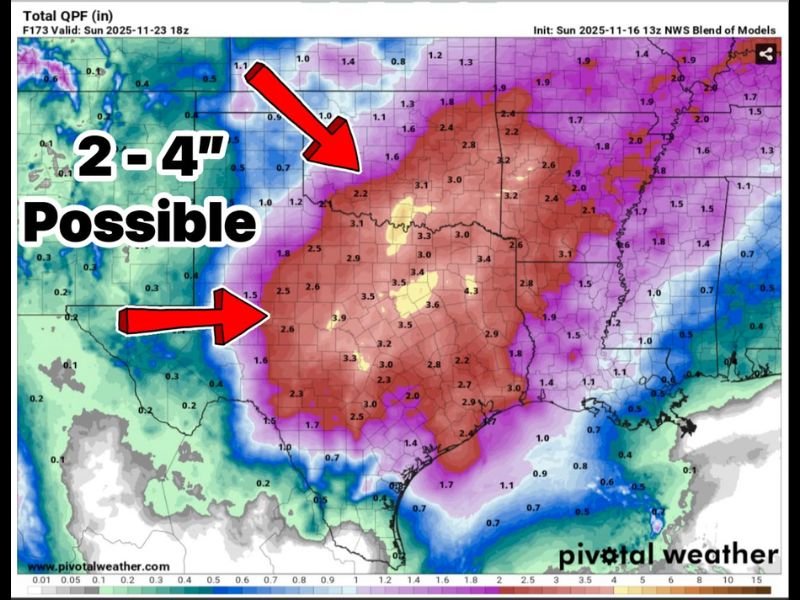
Rainfall Totals and the Regions Most at Risk
Based on the latest blend of National Weather Service models, a large portion of Texas is projected to receive 2 to 4 inches of total rainfall, with isolated pockets potentially seeing even higher amounts. The strongest rainfall signal stretches across:
- Central Texas
- North Texas
- East Texas
- Portions of Oklahoma and the ArkLaTex region
The QPF (Quantitative Precipitation Forecast) model imagery highlights a broad red zone across Texas, indicating widespread heavy accumulation. Areas under repeated thunderstorm development will face the highest flood risk.
Forecasters say they will refine rainfall estimates as new data arrives over the next 24–48 hours, especially as the timing of individual thunderstorms becomes clearer.
If you want continuing updates on major storm systems, rainfall projections, and severe weather alerts, stay connected with NapervilleLocal.com for the latest forecasts and safety guidance.

I’ve lived in Naperville long enough to see how quickly our community changes — from new developments downtown to sudden shifts in our Midwest weather. Reporting on Naperville news and daily forecasts gives me the chance to keep neighbors informed about what really matters. My goal is simple: deliver clear, timely updates so you always know what’s happening in our city and what to expect from the skies above.