
Texas Expected to See Increasing Storm Chances Next Week as Incoming Trough Boosts Instability and Raises Risk for Heavy Rainfall
TEXAS — Meteorologists say confidence is growing that a significant weather pattern change will impact Texas next week as a developing upper-level trough approaches from the west. This shifting setup is expected to increase instability, elevate storm chances, and potentially bring heavy rainfall, with some storms possibly reaching severe levels across parts of the state.
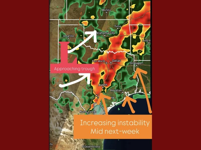
What the Developing Pattern Shows for Texas Next Week
Forecast models highlight an approaching trough sweeping into the Southern Plains, a feature often associated with strong lift, storm development, and enhanced moisture return from the Gulf of Mexico. With the trough shifting eastward, weather conditions across Texas are expected to become increasingly active by mid-week.
Key elements of the upcoming pattern include:
- An approaching upper-level trough creating widespread lift
- Deepening moisture streaming into Texas from the Gulf
- Increasing instability that can support thunderstorm growth
- Rising chances of heavy rainfall, especially across central and eastern Texas
Early forecast imagery shows clusters of rain and thunderstorms forming from Austin to Dallas, extending toward Houston and into areas near Shreveport, where instability is expected to be strongest.
Potential Impacts: Heavy Rain, Strong Storms, and Localized Flooding
As instability increases, Texas may see periods of heavy downpours, frequent lightning, and strong thunderstorms, particularly during the middle of next week. Meteorologists warn that if storms repeatedly track over the same areas, localized flooding could occur.
Possible hazards include:
- Heavy rainfall with quick accumulation
- Thunderstorms capable of strong wind gusts
- Localized flood potential in low-lying or poorly draining areas
- A marginal risk of severe weather, depending on how the trough interacts with surface moisture
While confidence is growing, forecasters caution that exact timing, rainfall totals, and risk areas will become clearer as next week approaches.
What Residents Should Watch Over the Coming Days
Meteorologists are closely monitoring changes in atmospheric instability as the trough approaches. A few important trends will determine how significant the mid-week event becomes:
- Moisture depth returning from the Gulf
- How quickly the trough sharpens as it moves east
- The position of surface boundaries that can trigger storms
- The degree of instability present during peak heating hours
If all ingredients align, parts of Texas could see multiple rounds of storms with periods of heavy rain from mid-week into late week.
For ongoing updates on severe weather risks, storm timing, and rainfall forecasts, stay connected with NapervilleLocal.com for the latest coverage.

I’ve lived in Naperville long enough to see how quickly our community changes — from new developments downtown to sudden shifts in our Midwest weather. Reporting on Naperville news and daily forecasts gives me the chance to keep neighbors informed about what really matters. My goal is simple: deliver clear, timely updates so you always know what’s happening in our city and what to expect from the skies above.