
Christmas Eve Weather Models Suggest Light Snow Possibilities Across the South, With Tennessee, Kentucky and the Carolinas Showing the Best Chances
UNITED STATES — Early long-range weather projections show a small but growing possibility of light snow across parts of the South on Christmas Eve, with the best chances focused on Tennessee, Kentucky, and portions of the Carolinas and Virginia. While confidence remains low this far out, model trends suggest a weak winter system may brush the region just before the holiday, potentially delivering light accumulation, flurries, or a brief dusting.
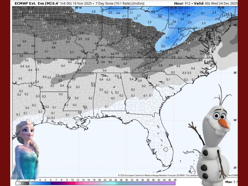
What the Early Snowfall Projection Map Shows
The ECMWF extended-range model displays a narrow corridor of light snow accumulation stretching from Arkansas into Tennessee, then northeast into Kentucky, Virginia, and the Carolinas. Accumulation amounts remain very low, with most regions showing only 0.1 to 0.5 inches, and isolated pockets near 1 inch in higher elevations or colder areas.
Key early signals include:
- Tennessee & Kentucky: The highest chance for measurable snow, potentially enough for light sledding in localized spots.
- Carolinas & Virginia: A light dusting possible, described as “powdered sugar on a donut” in early commentary.
- Deep South: Very small chances—just a few flurries on the northern edge of the system.
Meteorologists caution that these projections are highly speculative, but they are consistent enough to confirm early model interest.
Why Confidence Is Low This Far Ahead
Forecasters emphasize that extended-range snowfall projections around major holidays often fluctuate significantly. At 30+ days out, small shifts in storm track, temperature profiles, or moisture availability can eliminate or enhance snow chances entirely.
Important forecasting limitations include:
- Long-range models struggle with winter precipitation accuracy
- Snow forecasts at this range are trend-based, not event-based
- Small temperature changes can shift areas from snow to cold rain
- Tracks of weak holiday systems often change repeatedly until 3–5 days before arrival
Meteorologists note that models are “trying” to signal something, but it is too early to determine whether the South will actually see a white Christmas Eve.
What Could Influence the Holiday Forecast
A few atmospheric factors will determine whether Christmas Eve snow materializes:
- Positioning of a weak trough sliding across the central U.S.
- Availability of sufficient cold air at the surface
- Moisture transport from the Gulf of Mexico
- Whether the system stays open and weak, or strengthens while approaching the Appalachians
If temperatures dip just enough, parts of Tennessee, Kentucky, and the Appalachians could briefly transition to snow, especially at night.
However, many southern locations could instead experience:
- Cold rain
- Mixed precipitation
- No significant precipitation at all
More reliable outlooks will emerge 10–14 days before Christmas.
For ongoing holiday forecast updates, winter storm developments, and long-range model trends, stay connected with NapervilleLocal.com for the latest weather coverage.

I’ve lived in Naperville long enough to see how quickly our community changes — from new developments downtown to sudden shifts in our Midwest weather. Reporting on Naperville news and daily forecasts gives me the chance to keep neighbors informed about what really matters. My goal is simple: deliver clear, timely updates so you always know what’s happening in our city and what to expect from the skies above.