
Widespread Heavy Rain Expected Through Sunday as Storm System Targets Texas, Arkansas, Tennessee and Kentucky With Several Inches of Accumulation
UNITED STATES — A large, slow-moving storm system is expected to bring widespread heavy rainfall across parts of the South and lower Midwest now through Sunday, with the highest totals aimed at Texas, Arkansas, Tennessee, and Kentucky. Forecast maps show multiple rounds of rain spreading across the region, with the potential for several inches of accumulation and periods of localized flooding where storms repeatedly track over the same areas.
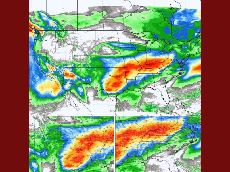
Forecast Models Show Widespread Heavy Rainfall Through the Weekend
According to the latest model projections, moisture streaming north from the Gulf of Mexico will fuel a broad corridor of moderate to heavy rain stretching from eastern Texas into the lower Mississippi Valley and northward into the Ohio Valley.
Key forecast highlights include:
- Texas appears likely to see the heaviest rainfall, with widespread multi-inch totals.
- Arkansas, Tennessee and Kentucky are projected to receive significant rainfall, with some areas seeing 2–4 inches or more.
- Rainfall bands may intensify as embedded thunderstorms enhance localized totals.
- The Gulf Coast is expected to receive lighter amounts but will still see intermittent showers.
Forecast maps show a concentrated zone of orange and red shading, indicating high precipitation totals where the atmosphere remains deeply saturated and storm energy is strongest.
Flooding Risk Elevated Where Storms Repeatedly Track
Meteorologists caution that the biggest concern may be storm training, where repeated rounds of rainfall pass over the same communities. This can quickly overwhelm drainage systems and lead to flash flooding, especially in urban areas or low-lying regions.
Flood-related concerns include:
- Urban flooding in cities with poor drainage
- Rapid runoff in hilly or mountainous regions
- Rising creek and stream levels across the mid-South
- Potential travel delays due to water-covered roads
Residents planning travel or outdoor activities from now through Sunday should monitor local forecasts closely.
What Residents Across the Region Should Expect
Areas under the heaviest rainfall corridor may experience:
- Periods of heavy downpours
- Thunderstorms embedded within rain bands
- Reduced visibility during the heaviest rain
- Water-slicked roads and hazardous driving conditions
- Saturated soil leading to standing water in yards and fields
Even locations that do not fall under the heaviest rainfall axis will still experience several rounds of showers, contributing to a soggy weekend for much of the South and Midwest.
More detailed rainfall totals and updated track forecasts will be released as the system continues to develop.
For continuous updates on this storm system, rainfall projections, and safety alerts across the region, stay connected with NapervilleLocal.com.

I’ve lived in Naperville long enough to see how quickly our community changes — from new developments downtown to sudden shifts in our Midwest weather. Reporting on Naperville news and daily forecasts gives me the chance to keep neighbors informed about what really matters. My goal is simple: deliver clear, timely updates so you always know what’s happening in our city and what to expect from the skies above.