
EURO Weather Model Shows Surprise January Snow Potential Across the Gulf Coast and Southern U.S., With Heavier Totals Further North
UNITED STATES — Long-range EURO weather model projections are catching attention across the country after suggesting a surprising early-January snow setup that stretches from the Southern Plains to the Ohio Valley — and even includes light snow potential along the Gulf Coast. While accumulations near the coast appear minimal, forecasters note that any snow in this region is rare, making its appearance on long-range guidance a notable development.
EURO Model Shows Light Snow Possible Near the Gulf Coast
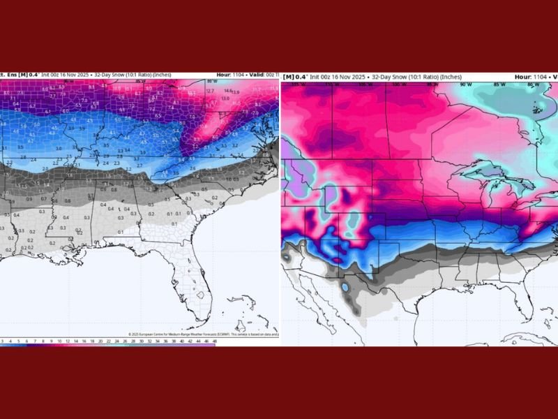
Meteorologists analyzing the latest EURO extended snowfall maps highlight a thin band of light grey shading along the Gulf Coast — indicating 0.1 to 1 inch of snow possible.
While this amount is minimal, it is still enough to cause excitement — and possibly some panic shopping — in regions unaccustomed to frozen precipitation.
Key interpretations from the color scale include:
- Light Grey (0.1–1 inch): Traceable snow, common in marginal Gulf Coast setups
- Darker Grey (1–3 inches): Enough for visible accumulation in northern Mississippi, Alabama, and Georgia
- Light Blue (2–4 inches): A level that would prompt school cancellations in much of the South
- Dark Blue (4–7 inches): Significant impacts, including travel disruptions and snow-covered roads
- Purple/Pink (8–14+ inches): Heavy snow territory across the Midwest, Great Lakes, and parts of the Appalachian region
The EURO model suggests that all of this may unfold by January 1st, signaling the potential for an active and colder start to 2026.
Heavier Snowfall Targets Midwest and Ohio Valley
While the Gulf Coast grabs early attention for its rarity, the heaviest projected snowfall remains further north. According to the long-range model output, the Midwest, Great Lakes, and northern Ohio Valley could see:
- 8 to 14+ inches in the deeper purple/pink zones
- Widespread 4 to 7 inches in surrounding regions
- Consistent snow coverage across central and eastern states
For snow-reliant areas in the Midwest, these projections align with typical early-winter patterns — though totals this high would still bring significant travel impacts.
What Makes This Setup Unusual?
Meteorologists say the unusual part of this EURO model run is not the heavy snow in the north, but the light snow potential in areas that seldom see flakes, including:
- Southern Louisiana
- Coastal Mississippi
- Southern Alabama
- The Florida Panhandle
Even a dusting in these locations can cause:
- Road closures
- Business delays
- High demand for winter supplies
- Widespread excitement — or concern — among residents
While this projection is still long-range and subject to major shifts, weather experts note that just appearing on EURO output is notable.
Long-Range Forecasts Always Carry Uncertainty
Forecasters caution that 32-day model runs are not precise forecasts, but rather guidance tools showing pattern possibilities. Snowfall totals, storm tracks, and temperature profiles can change significantly as January approaches.
Still, meteorologists say this model run offers one key takeaway:
The Gulf Coast isn’t expecting much snow — but the fact it even shows up on the map is a win for winter-weather enthusiasts.
Looking Ahead
With more model updates expected through late November and December, forecasters will continue watching whether this snowy southern signal remains consistent or fades in later runs.
For ongoing winter weather projections, snow outlooks, and national temperature trends, stay connected with NapervilleLocal.com.

I’ve lived in Naperville long enough to see how quickly our community changes — from new developments downtown to sudden shifts in our Midwest weather. Reporting on Naperville news and daily forecasts gives me the chance to keep neighbors informed about what really matters. My goal is simple: deliver clear, timely updates so you always know what’s happening in our city and what to expect from the skies above.