
Kentucky, Southern Illinois, and Indiana Under Tornado Watch as Storms Threaten Large Hail and Damaging Winds
KENTUCKY — A tornado threat is developing across western Kentucky, southern Illinois, and southern Indiana as forecasters warn that unstable atmospheric conditions could trigger a few isolated tornadoes late today.
According to Live Storm Chasers, any long-lived supercell storm could produce large hail and pockets of damaging wind, while a few storms may briefly spin up tornadoes, particularly along the warm front stretching from Cape Girardeau, Missouri to Louisville, Kentucky.
Areas at Risk
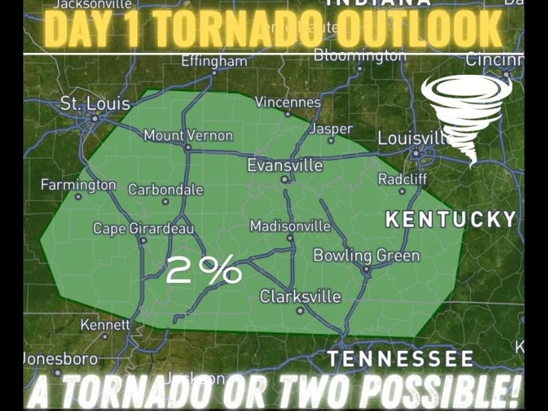
The Storm Prediction Center’s Day 1 Tornado Outlook highlights a 2% risk zone that includes:
- Cape Girardeau, Missouri
- Carbondale and Mount Vernon, Illinois
- Evansville and Jasper, Indiana
- Madisonville, Bowling Green, and Louisville, Kentucky
While this may sound low, meteorologists emphasize that even a 2% tornado probability can produce dangerous, fast-developing storms.
“If enough low-level instability builds farther north along the warm front, combined with stronger low-level shear, one or two tornadoes are possible,” meteorologists said in their afternoon discussion.
Timing and Threats
Storms are expected to develop through the afternoon and evening hours, with the strongest activity focusing in western Kentucky and southern Illinois. Elevated storms north of the front may produce hail and gusty winds, while surface-based storms near the boundary have the potential to rotate and produce brief tornadoes.
Key hazards include:
- Large hail up to 1 inch in diameter
- Damaging wind gusts exceeding 50 mph
- Brief tornadoes, especially along boundary zones
What Residents Should Do
Residents in the watch area are urged to:
- Monitor local weather alerts and radar updates closely.
- Have a safe shelter plan ready in case a warning is issued.
- Avoid traveling during active storm periods, particularly between 5 p.m. and midnight when instability peaks.
Meteorologists note that southern Indiana and central Illinois could also experience strong thunderstorms north of the warm front, though the tornado risk there is lower.
Stay Weather-Aware
Forecasters urge the public to remain alert, even if skies appear calm ahead of the main line. “It only takes one storm to produce serious damage,” weather experts warned.
Stay tuned for live radar and updates on developing severe weather conditions at NapervilleLocal.com.

I’ve lived in Naperville long enough to see how quickly our community changes — from new developments downtown to sudden shifts in our Midwest weather. Reporting on Naperville news and daily forecasts gives me the chance to keep neighbors informed about what really matters. My goal is simple: deliver clear, timely updates so you always know what’s happening in our city and what to expect from the skies above.