
Texas and Southern Oklahoma Face Severe Weather Threat Wednesday: Golf Ball-Sized Hail and 60 MPH Winds Possible
TEXAS — Forecasters are warning of severe thunderstorms developing Wednesday afternoon through late night across southern Oklahoma and central to northern Texas, with the potential for large hail, strong winds, and localized flooding.
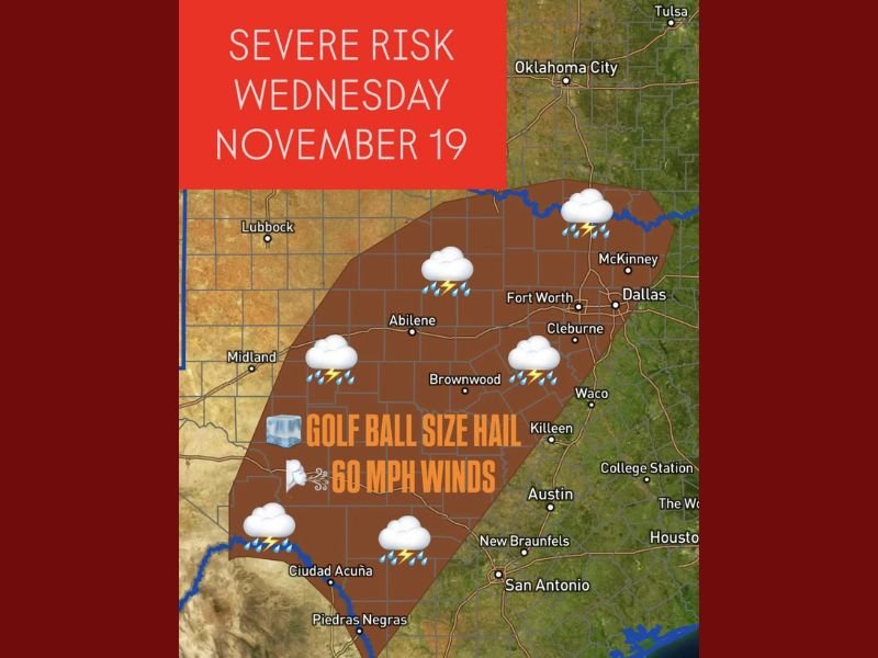
Meteorologists say the storms will form along an advancing cold front, fueled by warm, moist Gulf air that will create unstable conditions through the day. Some of these storms could turn severe, bringing hail as large as golf balls and wind gusts exceeding 60 mph across parts of Abilene, Fort Worth, and Brownwood.
Strong to Severe Storms Expected Mid-Afternoon into Late Evening
The latest model data shows storms forming by mid to late Wednesday afternoon, initially developing over central and west Texas, then moving eastward through Fort Worth, Dallas, and Waco into the overnight hours.
- Primary Hazards: Large hail up to 1.75 inches in diameter, damaging wind gusts, and intense lightning.
- Flood Risk: Localized flooding may occur in low-lying and urban areas, especially where heavy rain falls repeatedly over the same locations.
- Timing: Strongest storms are expected between 4 p.m. and midnight, with activity tapering off by early Thursday morning.
The National Weather Service highlights a “Severe Risk” zone stretching from southern Oklahoma through central Texas, including Abilene, Fort Worth, and San Antonio, where the most intense storms could occur.
Key Areas at Risk
- Fort Worth–Dallas Metroplex: Expect storms capable of damaging winds and hail late Wednesday evening.
- Central Texas (Abilene, Brownwood, Waco): Highest potential for golf ball-sized hail and short-lived tornado activity.
- Southern Oklahoma: Storms may develop rapidly late in the afternoon, moving southward into Texas overnight.
- San Antonio and Austin: Likely to see strong thunderstorms later in the evening, with heavy rainfall and lightning.
Meteorologists note that upper-level energy from the west is combining with surface moisture from the Gulf of Mexico, creating the ideal setup for volatile storm conditions across the region.
Residents Urged to Prepare Ahead of the Storm
Emergency management officials urge residents to stay weather-aware and review safety plans.
- Secure outdoor furniture and vehicles before storms develop.
- Avoid driving through flooded roadways; even shallow water can be dangerous.
- Keep flashlights and mobile alerts ready in case of power outages or late-night warnings.
The system will continue eastward into Thursday, bringing showers and isolated thunderstorms to parts of eastern Texas and western Louisiana, though the severe threat should diminish by then.
Stay tuned to NapervilleLocal.com for continued updates and official warnings from the National Weather Service as this severe weather event unfolds.

I’ve lived in Naperville long enough to see how quickly our community changes — from new developments downtown to sudden shifts in our Midwest weather. Reporting on Naperville news and daily forecasts gives me the chance to keep neighbors informed about what really matters. My goal is simple: deliver clear, timely updates so you always know what’s happening in our city and what to expect from the skies above.