
North Texas Braces for Intense Midweek Thunderstorms with Heavy Rain, Strong Winds, and Frequent Lightning
DALLAS–FORT WORTH, TEXAS — Residents across North Texas should prepare for a stretch of active and potentially hazardous weather beginning Wednesday night through Thursday night, as a strengthening storm system brings frequent lightning, strong winds, and torrential rainfall to the region.
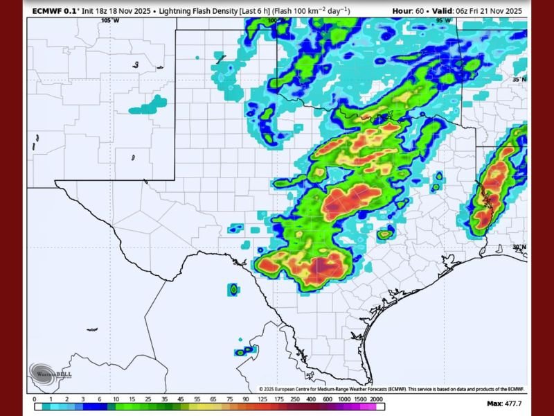
Forecasters say that storm energy is ramping up fast, with lightning flash density maps already lighting up across the Dallas–Fort Worth area and much of central Texas. The system will likely trigger multiple rounds of thunderstorms, some of which could produce small hail and intense rainfall rates.
Forecast Models Indicate Active Lightning and Heavy Rain Setup
According to the European Centre for Medium-Range Weather Forecasts (ECMWF), high lightning flash density is expected across north and central Texas, particularly from Wednesday evening into early Friday morning.
- Frequent lightning is expected as storms repeatedly develop over the same areas.
- Strong, sudden wind gusts could impact cities including Dallas, Fort Worth, and Waco, with the potential to cause brief power outages or downed branches.
- Very heavy downpours are forecast, with the strongest storm cores capable of producing rainfall rates up to 2 inches per hour.
- Pockets of small hail are possible within the strongest thunderstorms.
- Training storm bands — lines of storms that move slowly over the same area — could stack up rainfall totals and raise flash flood risks overnight.
Flooding and Travel Concerns
With such heavy rainfall projected, the National Weather Service warns that flash flooding could become a concern across low-lying areas, creeks, and urban streets. Motorists are urged to avoid driving through flooded roadways and stay alert for quickly changing conditions during commutes.
“Even areas that don’t typically flood could experience high water due to intense rainfall rates,” forecasters cautioned, noting that the DFW Metroplex may see the heaviest storms between Wednesday night and early Thursday morning.
What Residents Should Do
Officials recommend preparing now before the storms arrive:
- Charge electronic devices and keep flashlights ready in case of power interruptions.
- Stay indoors during lightning activity — lightning strikes remain a leading weather-related hazard in Texas.
- Avoid flooded areas and monitor local alerts for real-time weather updates.
This week’s system marks the latest in a series of active fall storm patterns sweeping through Texas, as warm Gulf moisture collides with a powerful cold front from the west.
Residents are encouraged to remain weather-aware through Thursday and check local forecasts regularly for updated alerts.
Stay with NapervilleLocal.com for continued updates and safety information on severe weather events across the U.S.

I’ve lived in Naperville long enough to see how quickly our community changes — from new developments downtown to sudden shifts in our Midwest weather. Reporting on Naperville news and daily forecasts gives me the chance to keep neighbors informed about what really matters. My goal is simple: deliver clear, timely updates so you always know what’s happening in our city and what to expect from the skies above.