
Texas and Central U.S. to Face Brutal Start to December as Second Arctic Blast Targets Region
DALLAS, TEXAS — The start of December is shaping up to be brutally cold across much of the Central United States, as new long-range model data points to a second, even stronger Arctic blast sweeping down from Canada into the Southern Plains.
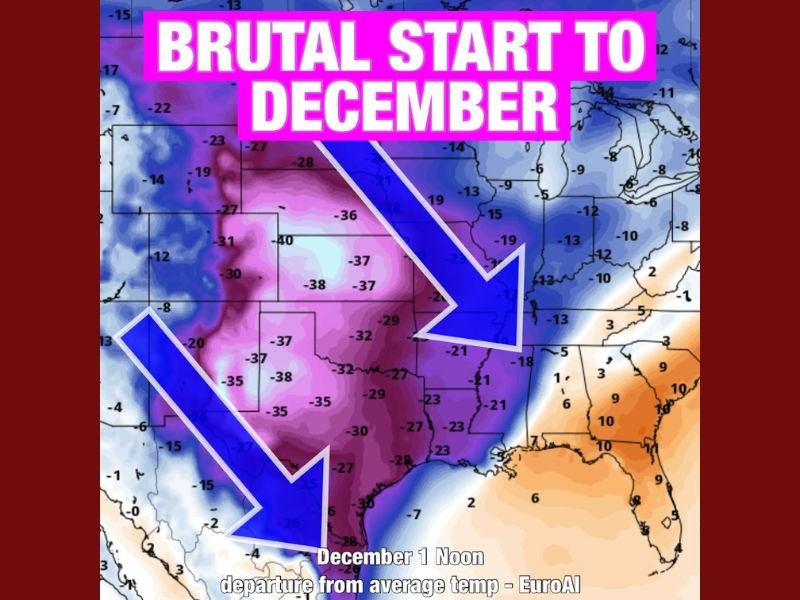
Meteorologists say this next round of cold air will follow closely behind the Thanksgiving week chill, plunging temperatures across Texas, Oklahoma, Kansas, and parts of the Midwest to 30–40 degrees below average in some areas.
Polar Vortex Disruption to Bring Widespread Arctic Air
According to the EuroAI long-range model, the pattern is being driven by a polar vortex disruption, which allows waves of Arctic air to spill southward repeatedly through early December. This setup could bring a prolonged period of below-freezing conditions and bitter wind chills for millions across the central and southern U.S.
The coldest air is expected to arrive around December 1, with model projections showing:
- Texas and Oklahoma dropping 25–40°F below normal.
- Kansas and Missouri facing highs struggling to reach the 20s in some regions.
- Arkansas and northern Louisiana likely seeing temperatures 15–25°F below average.
“This isn’t your typical early-winter chill — this is a deep Arctic outbreak with staying power,” meteorologists warn, noting that the cold air mass could linger for several days and possibly return in waves through mid-December.
Central and Southern States Prepare for Extreme Cold
Residents across Texas, Oklahoma, and Arkansas are urged to prepare early for potential freezing conditions, especially given recent warmth that could make the shock more noticeable.
- Pipes and irrigation systems should be insulated before the temperature drop.
- Pets and livestock need adequate shelter from cold winds and frost.
- Energy demand may spike as households rely heavily on heating systems.
While the coldest core of the air mass will target the Southern Plains, impacts could stretch north into Nebraska and Iowa and east into parts of Tennessee and Kentucky.
Early Signs of a Long Cold Stretch Ahead
Meteorologists emphasize that this Arctic blast may not be a one-time event. The EuroAI outlook suggests multiple surges of cold air into the continental U.S. through early to mid-December, potentially keeping temperatures well below normal for much of the country.
“The Thanksgiving cold front was just the opening act,” one forecaster noted. “This next Arctic plunge could redefine what ‘early winter’ feels like this year.”
Residents are encouraged to monitor local forecasts as model guidance becomes more precise, especially for snow or ice potential that could develop on the northern edge of the Arctic air mass.
Stay with NapervilleLocal.com for continuous weather coverage and preparedness updates as December’s Arctic cold approaches.

I’ve lived in Naperville long enough to see how quickly our community changes — from new developments downtown to sudden shifts in our Midwest weather. Reporting on Naperville news and daily forecasts gives me the chance to keep neighbors informed about what really matters. My goal is simple: deliver clear, timely updates so you always know what’s happening in our city and what to expect from the skies above.