
Florida and Southern States to See Dual Thanksgiving Cold Fronts Bringing Sharp Temperature Drop
TALLAHASSEE, FLORIDA — Residents across the South and Gulf Coast should brace for a rapid shift in weather conditions this Thanksgiving week, as two cold fronts are forecast to arrive in quick succession. The result will be a sharp drop in temperatures, marking the end of the unseasonably warm spell much of the region has been enjoying.
Forecasters describe the upcoming system as a “double feature Thanksgiving cooldown,” with the first front expected to arrive by Thursday evening, followed by a stronger surge of cold air mid-next week.
Thanksgiving Front to Bring Sudden Chill
The first cold front is expected to move through the region on Thanksgiving evening, sliding across Louisiana, Alabama, Georgia, and Florida overnight. This initial push of cooler air will cause temperatures to drop sharply, especially in the western Gulf states.
Forecast models show temperatures plunging from the upper 70s and 80s into the 40s and 50s across much of the South by late Thursday night. The cooler air will arrive just in time for Black Friday, potentially leading to a chilly start for early morning shoppers.
While precipitation is not expected to be widespread, scattered showers may develop along the front as it sweeps through coastal areas.
Second Front to Deliver the Strongest Cold Air
The second and more powerful cold front is expected to arrive by Wednesday, November 27, bringing even colder air and ending the last traces of late-autumn warmth. Meteorologists suggest this front could be 10–15 degrees colder than the first, pulling frigid air deep into Florida, Georgia, and Alabama.
Models indicate temperatures across northern Florida and southern Georgia could drop into the upper 30s, while cities like Atlanta and Birmingham may see morning lows in the 20s.
“This one isn’t just a cool breeze,” one forecaster explained. “It’s the kind of cold that makes Florida residents dig through closets for sweaters they haven’t seen since February.”
The system may also bring gusty winds and patchy frost, particularly across inland parts of Alabama, Mississippi, and northern Florida by Thursday morning.
A Sudden End to Fall Warmth Across the South
The dual cold fronts will mark a definitive end to the mild fall conditions that have lingered across the South for most of November. Meteorologists note that this sharp cooldown aligns with a broader pattern change expected nationwide as Arctic air builds behind the front.
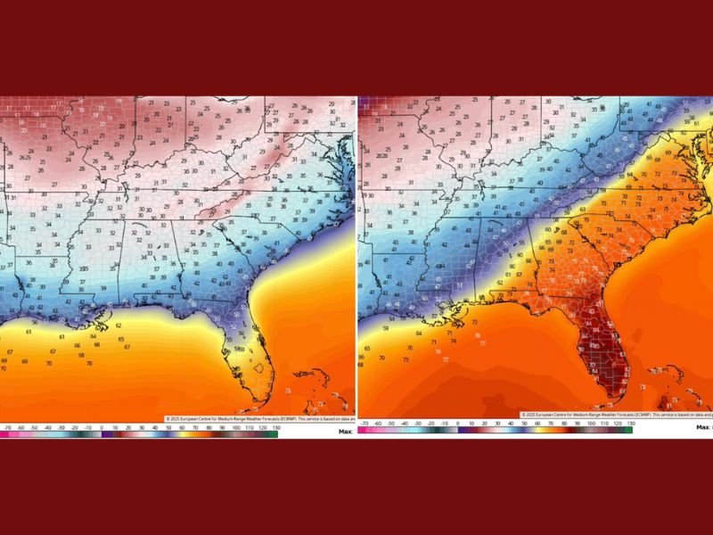
The latest model data from the European Centre for Medium-Range Weather Forecasts (ECMWF) shows temperature drops of 20 to 30 degrees in some areas between Thursday and the following Wednesday.
In Florida, residents could experience a dramatic swing from beach weather to winter chill, with highs in the 80s early in the week plummeting into the 50s by the end.
How to Prepare for the Thanksgiving Week Chill
Residents planning to travel or host outdoor events should plan for rapidly changing temperatures and bring extra layers for evening gatherings. Homeowners in northern parts of the region should also take precautions against early frost and pipe freezing, particularly as nighttime lows approach freezing later in the week.
While no major storm system is expected, the temperature plunge could affect holiday travel, particularly for those driving long distances across the region.
Stay tuned for continuing coverage and forecast updates as the Thanksgiving cold fronts approach. For the latest local weather reports and travel advisories, visit NapervilleLocal.com for complete updates throughout the week.

I’ve lived in Naperville long enough to see how quickly our community changes — from new developments downtown to sudden shifts in our Midwest weather. Reporting on Naperville news and daily forecasts gives me the chance to keep neighbors informed about what really matters. My goal is simple: deliver clear, timely updates so you always know what’s happening in our city and what to expect from the skies above.