
Washington State Braces for Lower Snow Levels and Colder Temperatures Ahead of Thanksgiving
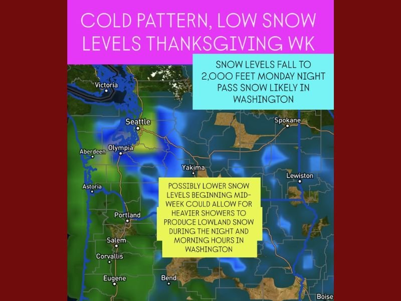
SEATTLE, WASHINGTON — A colder weather pattern is taking shape across Washington State heading into Thanksgiving week, with forecasters warning that snow levels could drop as low as 2,000 feet by late Monday night and possibly even lower as the week continues.
The developing cold front will bring pass-level snow and potential travel disruptions for those crossing the Cascades or heading east or west across the state in the days leading up to Thanksgiving.
Snow Levels Expected to Drop Rapidly
According to early model guidance, snow levels are projected to fall to around 2,000 feet by Monday night into Tuesday morning, just as many travelers begin their holiday journeys. Heavier showers during this cold pattern could briefly push snow levels even lower during the overnight and early morning hours mid-to-late week.
Meteorologists say the pattern is consistent with a classic late-November Arctic setup, where cold upper-level air sinks across the Pacific Northwest and interacts with lingering Pacific moisture. This can lead to bursts of low-elevation snowfall, particularly in areas such as Snoqualmie Pass, Stevens Pass, and the foothills near Olympia and Everett.
“We’re still a few days out from the details, but snow levels dropping this quickly means anyone driving over the passes should plan for slippery, snow-covered roads,” one forecaster noted Monday.
Possible Lowland Snow Midweek
By Wednesday through Friday, heavier showers could draw cold air downward, allowing snow to reach lower elevations overnight. While accumulation in the lowlands is uncertain, forecasters say there’s a chance of light snow mixing in across interior valleys west of the Cascades during the coldest nighttime hours.
The most likely impacts will occur in higher terrain and passes, where several inches of snow are possible. Early estimates suggest between 2 to 5 inches of snow accumulation for mountain passes through the middle of the week.
Travelers Urged to Prepare for Winter Conditions
With Thanksgiving travel expected to ramp up early in the week, officials are urging motorists to check pass reports and weather updates before heading out. Chains and winter tires may be required for travel through higher routes such as I-90 and US-2.
Drivers should plan extra time, pack emergency gear, and stay alert for changing conditions overnight, when temperatures will drop fastest.
The National Weather Service continues to monitor this evolving system and will issue updated advisories as confidence in snow levels increases.
Stay tuned for more forecast updates and travel alerts as Washington heads into a cold, snowy Thanksgiving week. For detailed weather coverage, visit NapervilleLocal.com for continued updates throughout the holiday period.

I’ve lived in Naperville long enough to see how quickly our community changes — from new developments downtown to sudden shifts in our Midwest weather. Reporting on Naperville news and daily forecasts gives me the chance to keep neighbors informed about what really matters. My goal is simple: deliver clear, timely updates so you always know what’s happening in our city and what to expect from the skies above.