
Texas, Louisiana, and Gulf Coast States Brace for Severe Storms, Tornado Threats, and Damaging Winds Ahead of Thanksgiving Week
GULF COAST — Residents across Texas, Louisiana, Arkansas, Mississippi, and Alabama are being warned to prepare for a powerful storm system forecast to bring tornadoes, damaging winds, and hail to the region on Monday, November 24, marking one of the most intense weather threats this month.
Meteorologists say the storm system is expected to strengthen over the Gulf, producing conditions capable of severe thunderstorms and localized flooding, just as millions begin their Thanksgiving travel.
Severe Weather Expected Across Multiple States
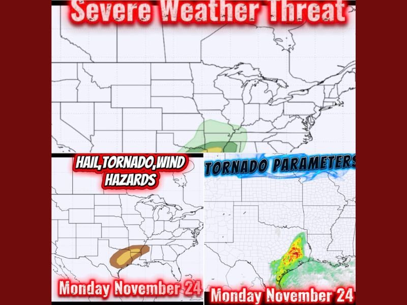
Forecast models show an expanding area of concern stretching from eastern Texas through Louisiana and into central Mississippi and Alabama, where atmospheric instability could trigger strong rotating thunderstorms and isolated tornadoes.
In addition to tornado potential, the region may see wind gusts exceeding 50 mph, capable of toppling trees, damaging roofs, and sending unsecured outdoor items airborne. Large hail is also possible in parts of southern Arkansas and western Louisiana.
“We’ve got severe storms, tornado potential, and hail that’ll beat your decorations like they owe it money,” one Gulf Coast forecaster wrote, urging residents to tie down outdoor Christmas decorations before the storms arrive.
Residents Warned To Secure Decorations and Outdoor Items
The timing of the storm—arriving just before Thanksgiving—has led many meteorologists to emphasize preparedness. High winds and heavy rain could impact travel and outdoor events, especially in Houston, Baton Rouge, Jackson, and Mobile.
“I don’t wanna wake up Monday to Rudolph in my neighbor’s ditch and Santa face-down in a pond,” another forecaster joked online, emphasizing the importance of securing holiday decorations before the system moves in.
What To Expect Monday
- Strong to severe thunderstorms beginning in east Texas and spreading eastward.
- Tornado risk highest from Shreveport to Jackson Monday afternoon through evening.
- Wind gusts up to 60 mph possible along the Gulf Coast, especially near Mobile and Biloxi.
- Hail and isolated flooding in low-lying and poorly drained areas.
Officials Urge Caution and Preparedness
Local emergency officials advise residents to monitor weather alerts, avoid unnecessary travel, and keep mobile devices charged in case of power outages.
“This isn’t just a rainstorm — this is a hold-my-cocoa, chase-your-decorations-down-the-street kind of weather,” one meteorologist warned.
The National Weather Service continues to monitor the system and will issue tornado and severe thunderstorm watches as conditions evolve.
Stay updated on weather alerts and safety information at NapervilleLocal.com.

I’ve lived in Naperville long enough to see how quickly our community changes — from new developments downtown to sudden shifts in our Midwest weather. Reporting on Naperville news and daily forecasts gives me the chance to keep neighbors informed about what really matters. My goal is simple: deliver clear, timely updates so you always know what’s happening in our city and what to expect from the skies above.