
Severe Weather Threat Expands: Texas, Louisiana, Mississippi, and Arkansas at Risk for Tornadoes and Rotating Supercells Monday Evening
TEXAS — Meteorologists are warning residents across Texas, Louisiana, Mississippi, and Arkansas to prepare for a potentially dangerous severe weather outbreak late Monday afternoon through the evening, with conditions primed for supercell thunderstorms, rotating updrafts, and tornado formation.
Weather models show a volatile setup developing as strong upper-level winds, Gulf moisture, and surface instability align over the region. This system could produce discrete, fast-moving storms capable of spawning tornadoes before merging into a line of damaging winds overnight.
Storm Zones and Structure
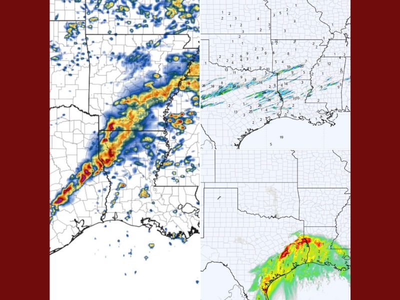
The first wave of storms is expected to form across eastern Texas and extend northeast through Louisiana, Mississippi, and into Arkansas. Bright red and orange zones on radar reflectivity maps show a broken line of storms capable of intense rotation — several of which could become supercells, the most dangerous type of thunderstorm associated with long-track tornadoes.
Forecasters caution that discrete storms — those not part of a larger complex — pose the greatest risk. “When these storms remain isolated, they have direct access to the unstable air and wind shear needed for tornado development,” a meteorologist explained in an online forecast update.
High Rotation Potential Across the Deep South
Helicity tracks — indicators of how long storms can maintain rotation — highlight a corridor from east Texas through northern Louisiana and central Mississippi, where the environment appears primed for sustained updrafts and tornado formation.
Atmospheric conditions including wind shear, moisture, and instability are all aligning for what experts describe as a “recipe for rotating storms.” Even if a tornado doesn’t strike a specific location, severe winds and large hail are still likely along this path.
Tornado Ingredients in Place
Tornado-parameter maps combine several key factors — moisture, lift, wind shear, and instability — to show where storms could rapidly spin up. Areas shaded in yellow, orange, and red across Texas, Louisiana, and Mississippi indicate the most favorable tornado environment.
“This doesn’t mean a tornado will hit every town in the highlighted zone,” the forecaster emphasized. “It means the atmosphere is ready. If a storm taps into the right ingredients, it can spin up quickly.”
Safety and Preparedness Tips
Residents across the risk zone are urged to:
- Have multiple ways to receive tornado warnings — including NOAA radios and mobile alerts.
- Don’t ignore notifications — if your phone alerts, act immediately.
- Know your safe place now, not when warnings are issued.
- Keep flashlights, batteries, and emergency supplies nearby in case of power outages.
Stay Alert as Conditions Evolve
The threat window extends through late Monday night, with storms likely continuing into early Tuesday for parts of the Lower Mississippi Valley.
Residents should remain alert, especially during evening hours when visibility is low.
Stay tuned to NapervilleLocal.com for updates as this developing system unfolds across the South.

I’ve lived in Naperville long enough to see how quickly our community changes — from new developments downtown to sudden shifts in our Midwest weather. Reporting on Naperville news and daily forecasts gives me the chance to keep neighbors informed about what really matters. My goal is simple: deliver clear, timely updates so you always know what’s happening in our city and what to expect from the skies above.