
Tornado-Warning Storm Approaches Jackson, Mississippi as Severe System Moves East at 45 MPH
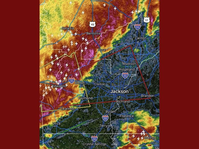
JACKSON, MISSISSIPPI — A severe thunderstorm capable of producing a tornado was detected early Tuesday morning near Edwards, about 10 miles west of Raymond, moving east at 45 miles per hour, according to the latest radar data.
At 1:59 a.m. CST, meteorologists issued a tornado warning as the storm intensified, with rotation signatures evident on Doppler radar. The storm’s path placed Clinton, Ridgeland, Madison, and Jackson in its projected impact area as it tracked rapidly eastward across Hinds County.
High Winds and Lightning Threat
Radar imagery showed heavy rainfall, intense lightning, and possible hail accompanying the storm. Wind gusts exceeding 60 mph were reported west of Jackson, with frequent cloud-to-ground lightning strikes illuminating the storm front across the I-20 corridor.
Areas including Flora, Bolton, and Raymond were under severe thunderstorm alerts, with residents urged to move indoors immediately and avoid travel until the system passes.
Officials Urge Nighttime Tornado Precautions
Meteorologists emphasized that nighttime tornadoes pose an increased danger, as many residents may be asleep and less likely to receive alerts. Jackson-area officials advised residents to keep phones charged and alerts activated, and to move to interior rooms or basements when warnings are issued.
“Overnight storms like this can turn deadly fast,” a local emergency official warned. “If you’re in the Jackson area, do not ignore the alerts — have a plan in place and stay alert.”
Storm Track and Expected Conditions
As of early morning, the storm remained part of a larger severe weather system sweeping across central Mississippi, with forecasters monitoring potential tornado development and damaging wind gusts eastward toward Brandon and Canton.
The National Weather Service continues to track the storm closely and is expected to update warnings as it moves into more populated areas.
For ongoing weather coverage and safety alerts across Mississippi and the Southeast, stay with NapervilleLocal.com.

I’ve lived in Naperville long enough to see how quickly our community changes — from new developments downtown to sudden shifts in our Midwest weather. Reporting on Naperville news and daily forecasts gives me the chance to keep neighbors informed about what really matters. My goal is simple: deliver clear, timely updates so you always know what’s happening in our city and what to expect from the skies above.