
Strong Storms Expected Across Texas, Oklahoma, Arkansas, and Louisiana as Arctic Front Arrives Saturday Afternoon
UNITED STATES — A surge of Arctic air pushing southward will meet warmer Gulf moisture on Saturday, sparking strong to severe thunderstorms across Texas, southeastern Oklahoma, Arkansas, and Louisiana. Forecast models indicate the potential for heavy rain, gusty winds, and isolated severe weather by Saturday afternoon and evening, particularly from central Texas to east Texas and into Louisiana.
Meteorologists warn that the storm line could intensify as it moves east, forming ahead of the advancing cold front and bringing disruptive weather to multiple states during the Thanksgiving weekend travel period.
Storms Forming Ahead of the Arctic Cold Front
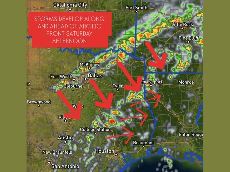
Weather guidance shows showers and storms developing along and out ahead of the approaching Arctic cold front beginning Saturday afternoon. The strongest storms are expected from Austin and College Station up through Dallas, Tyler, and Shreveport, spreading east into parts of Arkansas and Louisiana by evening.
Areas such as Fort Worth, Waco, and Beaumont are also likely to experience clusters of thunderstorms as the front sweeps through, potentially producing lightning, heavy rainfall, and strong wind gusts.
Forecasters are advising residents to stay alert to changing weather conditions throughout the day, as the collision of cold and warm air masses could trigger rapidly developing storms.
Threat of Severe Weather and Localized Flooding
While widespread severe weather is not guaranteed, forecasters note that some storms could reach severe limits, particularly in eastern Texas and western Louisiana, where warmer, more humid air will fuel instability.
Localized flooding is also possible in regions that experience repeated rounds of rain. Drivers traveling for post-Thanksgiving events are urged to use caution on highways and interstates, especially where heavy downpours reduce visibility.
The risk of isolated damaging winds and brief tornado-like rotation cannot be ruled out in stronger storm cells forming along the boundary.
Rapid Temperature Drop After the Front Passes
Behind the front, temperatures are expected to plummet sharply, with cold, dry air sweeping across the region by late Saturday night. Cities like Dallas, Austin, and Houston could experience a temperature drop of 20–25°F within hours of the frontal passage.
The arrival of the Arctic air mass will mark a significant pattern change heading into the final days of November, as the southern United States transitions abruptly from mild, humid weather to winter-like conditions.
Stay Weather Aware Through the Weekend
Forecasters recommend keeping updated through local alerts and monitoring weather radios or mobile notifications as the front advances. Travel delays are possible due to the combination of heavy rain and gusty winds.
Residents in the affected regions — especially central and eastern Texas through Louisiana — are urged to remain weather aware through Saturday afternoon and evening as conditions evolve.
Stay tuned to NapervilleLocal.com for verified national and regional weather developments as the Arctic front continues to move southward this weekend.

I’ve lived in Naperville long enough to see how quickly our community changes — from new developments downtown to sudden shifts in our Midwest weather. Reporting on Naperville news and daily forecasts gives me the chance to keep neighbors informed about what really matters. My goal is simple: deliver clear, timely updates so you always know what’s happening in our city and what to expect from the skies above.