
Major Winter Storm Warning Expands Across Wisconsin and Illinois With Up to 14 Inches of Snow Expected
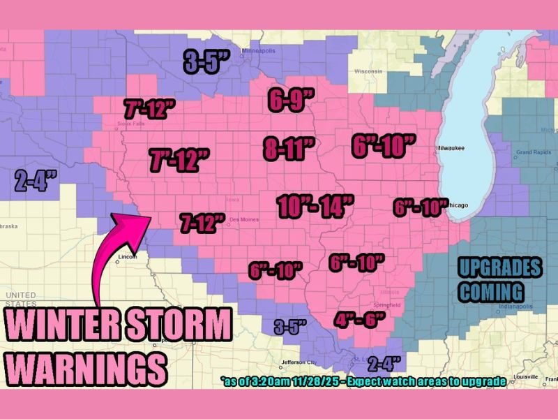
ILLINOIS — A significant winter storm is taking shape across the Upper Midwest, prompting expanded Winter Storm Warnings for large portions of Wisconsin and Illinois early Thursday morning. Forecast data shows widespread snowfall totals between 8 and 14 inches, with locally higher amounts possible in the heaviest snow bands stretching from central Iowa into northern Illinois and southern Wisconsin.
According to early-morning model updates, the storm will strengthen through Thursday and continue impacting the region into Friday, producing heavy, wet snow and hazardous travel conditions.
Heaviest Snow Bands Centered Over Illinois and Wisconsin
The latest forecast map shows the storm’s most intense snowfall concentrated from eastern Iowa through northern Illinois and southern Wisconsin, where totals could reach 10 to 14 inches in some locations.
Major cities including Chicago, Rockford, and Milwaukee fall within the 6–10 inch range, while areas farther west toward Des Moines and Sioux Falls could see totals between 7 and 12 inches. Meteorologists warn that snow rates may exceed 1 inch per hour during the height of the storm, drastically reducing visibility on major interstates such as I-80, I-90, and I-94.
Winter Storm Watches Extend East Into Indiana
Farther east, Winter Storm Watches remain in effect across much of Indiana, with forecasters expecting those alerts to be upgraded later Thursday morning. Depending on the storm’s track, parts of northern and central Indiana could experience 6 to 10 inches of snow as the system pushes eastward.
The southern edge of the storm will likely see rain mixing with snow, keeping accumulations closer to 4 to 6 inches. This mix will also make the snow heavier and more difficult to clear, increasing the risk of power line stress and minor outages in some areas.
Travel and Safety Concerns Through Friday
With widespread heavy snow expected, travel impacts are anticipated across Wisconsin, Illinois, Iowa, and Indiana. Roadways may quickly become snow-covered and slippery, and drivers are advised to avoid unnecessary travel during peak storm hours.
The National Weather Service urges residents to keep emergency kits, blankets, and extra food in their vehicles in case of delays or road closures. Visibility is likely to be poor during the height of the storm, particularly in open rural areas where blowing snow will reduce line of sight.
Heavy Snow to Taper by Friday Morning
The storm is forecast to gradually move east by Friday morning, with lingering snow showers possible across the Great Lakes region. Temperatures will remain below freezing, meaning snow accumulation will likely persist into the weekend.
Cleanup and snow removal efforts are expected to take time due to the storm’s broad reach and heavy moisture content. Residents are encouraged to shovel cautiously and stay aware of local weather advisories for post-storm cold and ice hazards.
Stay updated with NapervilleLocal.com for continued coverage, snowfall totals, and regional recovery updates as this major winter system moves through the Midwest.

I’ve lived in Naperville long enough to see how quickly our community changes — from new developments downtown to sudden shifts in our Midwest weather. Reporting on Naperville news and daily forecasts gives me the chance to keep neighbors informed about what really matters. My goal is simple: deliver clear, timely updates so you always know what’s happening in our city and what to expect from the skies above.