
Severe Weather Threatens Texas, Oklahoma, Arkansas, and Louisiana Saturday With Risk of Tornadoes, Hail, and Damaging Winds Ahead of Arctic Front
UNITED STATES — Meteorologists are warning of severe storms expected Saturday across Texas, southeastern Oklahoma, southwestern Arkansas, and Louisiana as an Arctic cold front sweeps through the southern United States. The system could bring tornadoes, large hail, strong winds, and heavy rain, impacting travel and outdoor plans throughout the region.
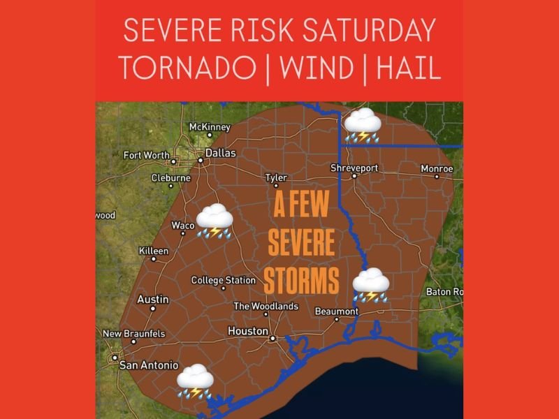
The severe weather threat is expected to begin around 2 p.m. Saturday and continue through 2 a.m. Sunday, with storms shifting from northwest to southeast across the affected areas.
Tornadoes, Hail, and High Winds Possible
According to forecasters, unstable warm air from the Gulf will collide with the advancing Arctic front, fueling storms capable of producing rotating cells and isolated tornadoes. Some storms could also bring hail up to an inch in diameter and wind gusts reaching 60 mph or higher.
The greatest risks include property damage, power outages, and hazardous driving conditions as thunderstorms sweep across the region into late Saturday night. Meteorologists caution that even short-lived storms could cause significant localized damage.
Areas Under the Highest Risk
The broad storm risk area includes Austin, San Antonio, Waco, College Station, Houston, The Woodlands, Tyler, Shreveport, and Monroe, with Dallas and Fort Worth also likely to see strong storm activity before the front pushes eastward.
By Saturday evening, the severe threat will expand into southern Arkansas and western Louisiana, where strong winds and brief tornadoes are possible. Areas along major highways, including I-20, I-35, and I-45, should prepare for rapidly changing weather and potential travel disruptions.
Timing and Storm Path
The first storms are expected to develop in central and northern Texas during the afternoon hours before tracking eastward toward Louisiana overnight. The front will move southeast through the early morning hours on Sunday, leaving behind much colder and drier air across the Southern Plains.
Residents should secure outdoor items and prepare for a noticeable temperature drop following the storm’s passage.
Safety Precautions and Forecast Outlook
Officials are urging residents across the Southern Plains and Lower Mississippi Valley to stay alert and monitor local weather alerts throughout the weekend. Meteorologists emphasize that these fast-moving storms could intensify quickly, leaving little time to seek shelter once warnings are issued.
Emergency management teams recommend keeping phones charged, flashlights ready, and a safe indoor shelter plan in place before Saturday afternoon.
As the Arctic front settles in behind the storms, temperatures across Texas and nearby states are expected to plunge by 20–30 degrees, marking the start of a colder, more winter-like pattern heading into next week.
Stay with NapervilleLocal.com for verified national and regional weather updates as the Arctic front and storm system move through the South.

I’ve lived in Naperville long enough to see how quickly our community changes — from new developments downtown to sudden shifts in our Midwest weather. Reporting on Naperville news and daily forecasts gives me the chance to keep neighbors informed about what really matters. My goal is simple: deliver clear, timely updates so you always know what’s happening in our city and what to expect from the skies above.