
Major Winter Storm to Blanket Midwest With 6–12 Inches of Snow, Threatening Travel Across Des Moines, Chicago, and Milwaukee
MIDWEST UNITED STATES — A powerful winter storm is forecast to impact much of the Midwest this weekend, bringing widespread snowfall totals of 6 to 12 inches or more across several states, including Iowa, Illinois, and Wisconsin. Meteorologists warn that the storm could cause dangerous travel conditions across major metro areas such as Des Moines, Chicago, and Milwaukee through late Sunday.
According to the National Weather Service, the system will strengthen rapidly as it moves east, spreading heavy snow and strong winds from the central Plains into the Great Lakes region. Forecasters say the greatest impacts are expected from Saturday evening through early Monday, with travel likely to become hazardous or even impossible in some areas.
Heavy Snowfall Expected Across the Upper Midwest
Current projections show the heaviest snowfall across central and eastern Iowa, northern Illinois, and southern Wisconsin, where totals could exceed a foot of snow in some locations. Cities including Des Moines, Iowa City, Cedar Rapids, Rockford, Chicago, and Milwaukee are all under winter storm alerts, with meteorologists urging residents to prepare for low visibility, blowing snow, and icy roadways.
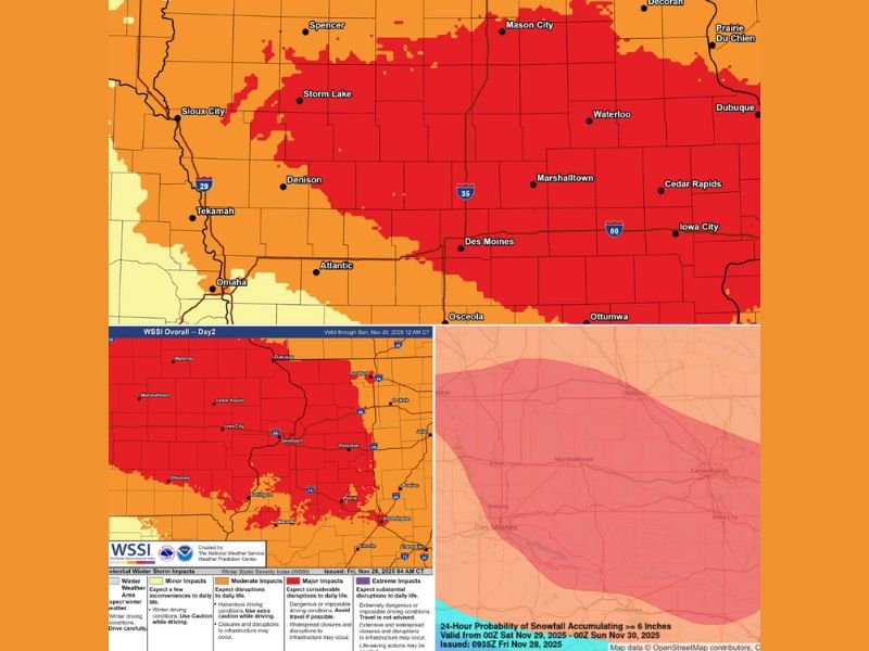
Forecast graphics show widespread red zones indicating major to extreme storm impacts, particularly across Iowa and northern Illinois. In these areas, even short-distance travel could become treacherous as roads become snow-covered and drifting snow reduces visibility.
Travel Impacts and Safety Concerns
The Winter Storm Severity Index (WSSI) classifies much of the central Midwest under “major” and “extreme” impact levels, meaning travel disruptions, stranded motorists, and temporary road closures are possible. Authorities are urging drivers to avoid unnecessary travel during the storm and to keep emergency kits, blankets, and chargers in vehicles if travel cannot be postponed.
In addition to the heavy snow, gusty winds behind the system could create near whiteout conditions in open areas, particularly across rural stretches of Iowa and Illinois. Snowplows and emergency services are preparing for prolonged cleanup operations as accumulations continue through the weekend.
Probability of Six Inches or More of Snow
Weather models indicate a high probability (greater than 70%) of at least six inches of snow across large portions of Iowa, Illinois, and southern Wisconsin. Areas near Des Moines, Cedar Rapids, and Davenport are especially likely to see the heaviest accumulation before the storm shifts eastward into northern Illinois and Wisconsin late Sunday.
Forecasters note that a narrow band of even heavier snowfall could develop along the storm’s center, producing totals closer to 12–14 inches in localized areas. The snow will be wet and heavy, increasing the risk of power outages due to falling tree limbs and added stress on power lines.
Residents Urged to Prepare Ahead of the Weekend
Officials across the region are urging residents to prepare now for disruptions to travel, business operations, and weekend events. Those planning holiday shopping or travel are advised to check local forecasts and consider rescheduling plans until conditions improve.
Meteorologists say temperatures will remain below freezing after the storm passes, allowing snow and ice to linger into next week. Wind chills are expected to dip into the teens and single digits across parts of the Midwest by Monday morning.
Summary of Key Impacts
- Snow totals: 6–12 inches widespread, up to 14 inches in some areas
- Timing: Saturday afternoon through Sunday night
- Main impact areas: Iowa, northern Illinois, southern Wisconsin
- Major cities affected: Des Moines, Chicago, Milwaukee
- Primary hazards: Heavy snow, blowing snow, near-zero visibility, slick roads
Residents are advised to stay tuned to local weather alerts and National Weather Service updates throughout the weekend as conditions develop.
Stay connected with NapervilleLocal.com for real-time weather coverage, forecast updates, and travel advisories as this major Midwest winter storm unfolds.

I’ve lived in Naperville long enough to see how quickly our community changes — from new developments downtown to sudden shifts in our Midwest weather. Reporting on Naperville news and daily forecasts gives me the chance to keep neighbors informed about what really matters. My goal is simple: deliver clear, timely updates so you always know what’s happening in our city and what to expect from the skies above.