
Major Snowstorm Expected Across Midwest and Great Lakes With 90% Chance of Accumulation From Nebraska to Ohio
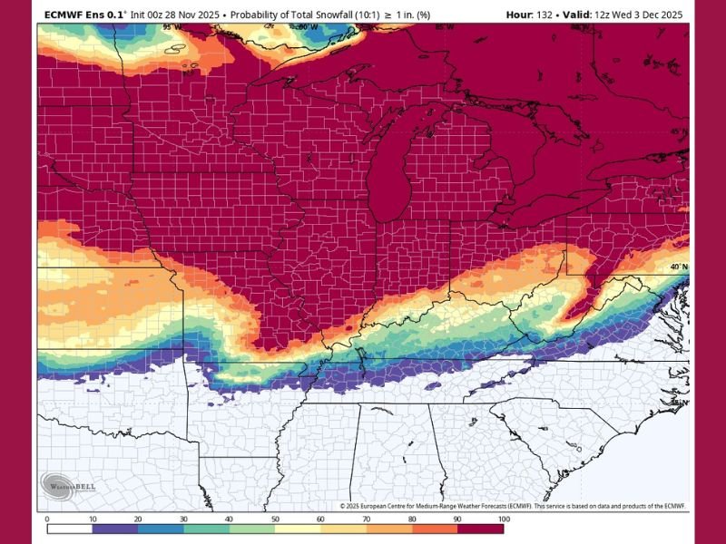
MIDWEST UNITED STATES — Winter weather models are signaling a high-probability snow event across much of the Midwest and Great Lakes region, with forecasts showing over a 90% chance of at least one inch of snow from Nebraska and Iowa through Illinois, Indiana, and into Ohio. The widespread storm system is expected to hit over the weekend, bringing the first major taste of winter to millions of residents.
Meteorologists say the strongest snowfall will arrive Saturday, with another system potentially adding fresh accumulation early next week. The storm is expected to stretch hundreds of miles, impacting both rural and urban areas, including Chicago, Indianapolis, Des Moines, and Cleveland.
High Probability of Snow Across the Region
Data from the European Centre for Medium-Range Weather Forecasts (ECMWF) shows a vast region of deep red shading — representing more than a 90% likelihood of measurable snow — covering much of the central and eastern Midwest. The probability map highlights a solid swath of high confidence extending from eastern Nebraska and central Iowa through northern Illinois and Indiana into northern Ohio.
Snowfall totals will vary by location, but the models consistently indicate 6 to 12 inches possible in heavier bands, with lighter amounts along the southern edge of the storm. Meteorologists caution that even 1–3 inches of snow in southern regions could create slippery roads and visibility issues, especially if temperatures fall quickly after sunset.
Travel Impacts Expected Saturday and Sunday
The National Weather Service warns that travel disruptions are likely as snow begins to accumulate Saturday afternoon and continues into Sunday. Major interstates, including I-80, I-90, I-94, and I-70, are expected to be affected by periods of snow, slick conditions, and reduced visibility.
Drivers across Illinois, Indiana, and Ohio are advised to allow extra time for travel, reduce speeds, and prepare for changing conditions. Snowplow crews across the Midwest are preparing for extended operations, especially in regions expected to receive the heaviest accumulation.
Residents in major metro areas such as Chicago, Milwaukee, Des Moines, and Cleveland may see their first significant snow totals of the season, potentially complicating weekend plans and early holiday shopping.
Possible Second System Early Next Week
While the majority of snow will fall during the weekend, forecasters are also tracking a secondary storm system that could move through the Great Lakes region by Monday, adding to snow totals in some areas.
Depending on the track of this follow-up system, parts of Michigan, northern Indiana, and Ohio could see another 1–3 inches of snow, prolonging travel difficulties and extending winter weather impacts into early next week.
Southern Edge Could See Mixed Precipitation
Along the southern boundary of the storm track — stretching from southern Missouri through Kentucky and West Virginia — some areas could experience a rain-snow mix, limiting snow accumulation but still creating slippery roadways. Forecasters note that minor changes in the storm’s path could shift these transition zones north or south, altering snowfall totals in nearby regions.
Residents Urged to Prepare for Hazardous Conditions
Officials across the Midwest are urging residents to monitor updated forecasts, ensure vehicles are winter-ready, and keep emergency kits on hand in case of travel delays or power outages. Meteorologists emphasize that even moderate snowfall can cause rapidly deteriorating road conditions, particularly during periods of heavier snow bands.
With temperatures expected to stay below freezing after the storm passes, snow and ice could linger through the start of December, reinforcing the season’s arrival across the Midwest.
Stay updated with NapervilleLocal.com for continuing coverage of this major winter storm, including regional snowfall totals, road advisories, and post-storm updates throughout the weekend.

I’ve lived in Naperville long enough to see how quickly our community changes — from new developments downtown to sudden shifts in our Midwest weather. Reporting on Naperville news and daily forecasts gives me the chance to keep neighbors informed about what really matters. My goal is simple: deliver clear, timely updates so you always know what’s happening in our city and what to expect from the skies above.