
Major Winter Storm to Slam Iowa, Illinois, and Wisconsin Saturday With Up to 18 Inches of Snow and Dangerous Travel Conditions
MIDWEST UNITED STATES — A powerful winter storm is forecast to deliver 12–18 inches of snow across Iowa, Illinois, and Wisconsin on Saturday, creating dangerous whiteout travel conditions across major highways and airports during one of the busiest post-Thanksgiving travel weekends of the year.
The National Weather Service warns that snowfall rates of 1–3 inches per hour could occur in the hardest-hit areas, making travel on Interstates 80 and 35 extremely difficult by Saturday afternoon. Forecasters say the system will also cause flight delays and cancellations across several Midwest airports as blizzard-like conditions develop.
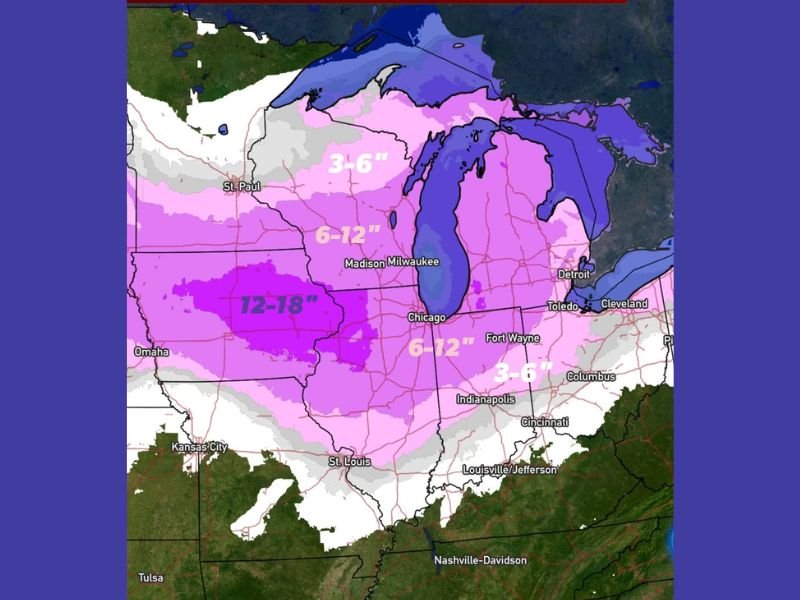
Heaviest Snow Centered in Iowa and Northern Illinois
Forecast maps show a wide area of heavy snow stretching from eastern Nebraska and central Iowa through northern Illinois into southern Wisconsin. The deepest accumulations — highlighted in dark purple on forecast charts — are expected across central Iowa, northwestern Illinois, and southern Wisconsin, where totals could reach or exceed 18 inches in localized bands.
Major cities in the storm’s direct path include Des Moines, Cedar Rapids, Rockford, Madison, Milwaukee, and Chicago. Surrounding regions across Indiana, Michigan, and Ohio are also likely to receive 3–6 inches of snow, with slippery roads and poor visibility expected into late Saturday night.
“This storm will hit during the peak of the holiday return rush,” meteorologists said. “Blowing snow and extremely low visibility will make road conditions treacherous across much of Iowa and northern Illinois.”
Travel Conditions Expected to Worsen by Midday Saturday
The snow is forecast to begin early Saturday morning in Iowa, spreading eastward through Illinois by midday and reaching Wisconsin and Michigan by the afternoon. Winds gusting between 25–35 mph will create whiteout conditions at times, making travel nearly impossible along major interstates including I-80, I-90, and I-94.
Drivers are urged to stay off the roads if possible and allow snowplows time to clear priority routes. Forecasters emphasize that the combination of heavy, wet snow and strong winds could also lead to scattered power outages and downed tree limbs.
Airline Delays and Cancellations Anticipated
Airports across the Midwest — including Chicago O’Hare, Des Moines International, and Milwaukee Mitchell — are expected to experience flight disruptions throughout the weekend. The storm’s widespread coverage means ripple effects could extend to airports in Florida, Georgia, and the East Coast, where travelers heading north may encounter delays.
Those returning home from Thanksgiving trips are advised to check flight statuses frequently and prepare for possible rebookings.
Forecast Breakdown by State
- Iowa: 12–18 inches expected; heaviest bands in Des Moines, Ames, and Cedar Rapids.
- Illinois: 6–12 inches for most areas, with heavier totals west of Chicago toward Rockford and the Quad Cities.
- Wisconsin: 8–14 inches possible, with the highest amounts near Madison and Milwaukee.
- Indiana and Michigan: 3–6 inches of accumulation, tapering off late Saturday night.
Coldest Air of the Season to Follow
Once the storm clears, a surge of Arctic air will sweep in behind it, dropping temperatures into the teens and single digits by Sunday morning. Wind chills could fall below zero across Iowa and northern Illinois, making for a frigid end to the holiday weekend.
Officials urge residents to prepare for hazardous travel, power outages, and freezing temperatures through early next week.
Stay with NapervilleLocal.com for continued updates on snowfall totals, travel advisories, and local alerts as this major Midwest winter storm unfolds.

I’ve lived in Naperville long enough to see how quickly our community changes — from new developments downtown to sudden shifts in our Midwest weather. Reporting on Naperville news and daily forecasts gives me the chance to keep neighbors informed about what really matters. My goal is simple: deliver clear, timely updates so you always know what’s happening in our city and what to expect from the skies above.