
Major Winter Storm to Blanket Colorado Mountains With Up to Two Feet of Snow Through Monday, Ending Prolonged Drought Conditions
COLORADO — After weeks of dry weather and minimal snowfall, Colorado is finally set to experience a major winter storm bringing up to two feet of snow across the state’s mountain regions through Monday. The system marks a dramatic shift from the recent snow drought that has left many ski areas struggling to open for the season.
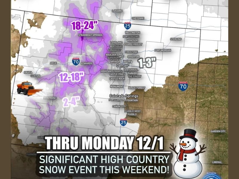
According to forecasters, the event will unfold in two main waves, with the first arriving Friday night into Saturday morning and the second — much heavier — moving through Sunday night into Monday.
Two Waves of Snow to Blanket the Rockies
The initial round will bring 2–6 inches of snow to the High Country by Saturday morning, setting the stage for the second system expected to produce an additional 12–24 inches across the northern and central mountains.
The heaviest totals are expected in and around Steamboat Springs, Vail, Breckenridge, and Aspen, where blizzard-like conditions could develop in higher elevations during the peak of the storm.
“The mountains will finally get a major boost of natural snow after a disappointing start to the season,” meteorologists said, noting that this will significantly improve ski conditions and regional water supply levels heading into December.
Denver and Front Range to See Lighter Accumulations
While the mountains will bear the brunt of the storm, the Denver metro area and Front Range communities can expect up to 2 inches of light snow, with localized bands near CO-470 seeing slightly higher totals.
Areas farther east, including the Eastern Plains, are forecast to receive little to no measurable accumulation, though gusty winds and colder temperatures will accompany the storm across the region.
Travel Impacts Expected in Mountain Passes
The Colorado Department of Transportation is urging drivers to prepare for hazardous travel conditions across major routes, including Interstate 70, U.S. 40, and U.S. 285, where heavy snow and reduced visibility could make driving treacherous through the weekend.
Officials recommend carrying tire chains, extra food and water, and avoiding unnecessary travel during periods of heaviest snowfall between Sunday night and early Monday.
Regional Snowfall Forecast
- Steamboat Springs to Walden: 18–24 inches
- Vail, Breckenridge, and Aspen areas: 12–18 inches
- Montrose and Gunnison: 2–4 inches
- Denver Metro: 0–2 inches, locally higher west of the city
- Eastern Plains: Light dusting possible, otherwise dry
Boost for Ski Resorts and Tourism
The storm’s timing couldn’t be better for ski resorts preparing for holiday travelers. The fresh snow will rejuvenate ski slopes across Summit County and beyond, providing optimal early-season conditions for resorts that have relied heavily on snowmaking.
Meteorologists note that temperatures will remain cold enough into early next week to preserve snowpack and improve base depths, marking a strong start to December’s ski season.
As forecasters put it: “Colorado’s mountains can finally exhale — this is the kind of storm they’ve been waiting for.”
For continued weather updates and regional travel advisories, visit NapervilleLocal.com for the latest forecasts and community reports.

I’ve lived in Naperville long enough to see how quickly our community changes — from new developments downtown to sudden shifts in our Midwest weather. Reporting on Naperville news and daily forecasts gives me the chance to keep neighbors informed about what really matters. My goal is simple: deliver clear, timely updates so you always know what’s happening in our city and what to expect from the skies above.