
Heavy Rain Pattern to Drench Alabama Through Mid-December, With Up to 7 Inches Possible in Central and Southern Regions
ALABAMA — A much-needed stretch of soaking rainfall is on the way for North, Central, and South Alabama, as an active storm pattern sets up through early and mid-December. Forecast models show that parts of the state could see 4 to 7 inches of total rainfall over the next two weeks, bringing a welcome break from recent dry conditions.
Meteorologists say the first wave of rain will arrive Sunday morning, mainly across North and Central Alabama, followed by another round Monday night into Tuesday. Additional rainfall is expected late next week, continuing a wet start to December that could keep soil moisture and reservoirs in the positive range heading into winter.
Multiple Rain Events Expected Over the Next 10 Days
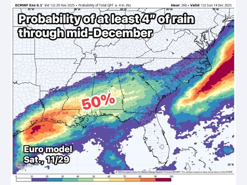
According to the European Centre for Medium-Range Weather Forecasts (ECMWF), Alabama is in the 50% probability zone for receiving at least 4 inches of rain between November 29 and December 14. The model highlights a concentrated band of moisture stretching from eastern Texas into southern Alabama, with the heaviest totals projected near the Gulf Coast and lower Central Alabama.
The current forecast calls for:
- 1.5 to 3 inches of rain across much of North and Central Alabama by next Saturday
- 4 to 7 inches possible in southern and coastal areas by mid-December
- Repeated rain chances early and late next week, extending into the second week of December
Forecasters note that this pattern could continue to bring steady rainfall every few days, making it likely that Alabama ends the first half of December above normal in precipitation totals.
Active Weather Pattern Linked to Persistent Gulf Moisture
Meteorologists attribute the ongoing rainfall to a persistent northwest-to-southeast flow aloft, which is allowing Gulf moisture to surge northward into the Deep South. Embedded disturbances within this flow are expected to trigger several waves of precipitation.
“The active weather pattern is expected to hold through at least mid-December,” meteorologists explained. “This setup favors multiple rounds of rain that could add up significantly over time.”
Residents in Montgomery, Birmingham, and Mobile can expect periods of heavy rain and occasional thunderstorms, though widespread severe weather is not currently anticipated. However, localized flooding could occur in low-lying or poorly drained areas if rainfall totals exceed forecasts.
Rain Relief After Dry Fall Conditions
The incoming rainfall offers a silver lining for Alabama farmers and communities that have dealt with drier-than-normal conditions through much of the fall. Soil moisture levels are expected to improve, and reservoir inflows will benefit as steady rain continues into December.
By the middle of the month, much of Central and South Alabama may total 4 to 7 inches of rainfall, marking a substantial improvement in overall drought indices heading toward the end of the year.
Stay informed on Alabama’s changing weather conditions and extended rain forecasts by visiting NapervilleLocal.com for continued updates.

I’ve lived in Naperville long enough to see how quickly our community changes — from new developments downtown to sudden shifts in our Midwest weather. Reporting on Naperville news and daily forecasts gives me the chance to keep neighbors informed about what really matters. My goal is simple: deliver clear, timely updates so you always know what’s happening in our city and what to expect from the skies above.