
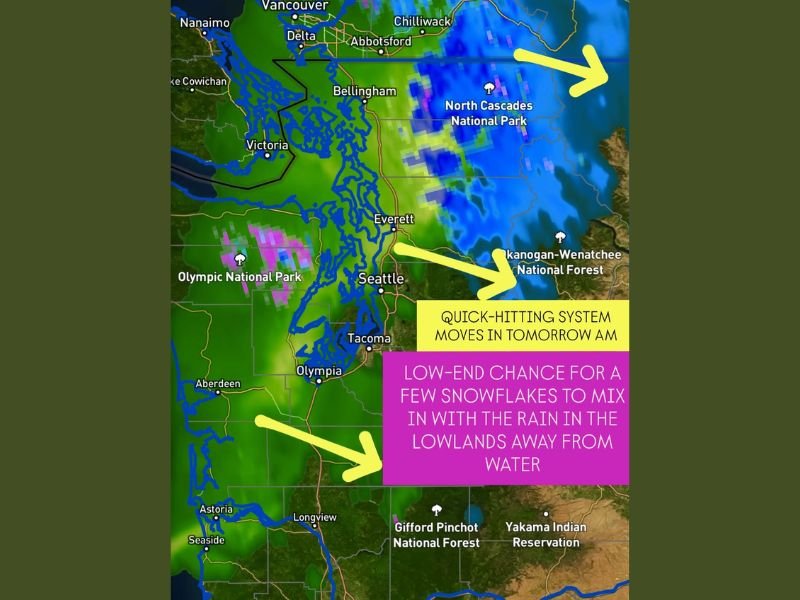
Quick-Hitting Storm to Bring Rain and Light Mountain Snow to Western Washington Monday Morning
WASHINGTON — A quick-hitting storm system is forecast to move across western Washington on Monday morning, delivering a mix of lowland rain showers and light mountain snow to start the week. While no major accumulations are expected, the system will bring slick roads and brief bursts of mixed precipitation for commuters across the region.
According to forecasters, the short-lived system will push inland from the Pacific Ocean, affecting areas from Seattle and Tacoma to Bellingham before tapering off by early afternoon.
Rain for Lowlands, Snow in the Mountains
The Olympic Mountains and Cascades are expected to see a few inches of new snow, particularly around North Cascades National Park and Mount Rainier National Park, where temperatures will remain cold enough for light accumulation.
In contrast, the Seattle metro area and other low-lying regions near Puget Sound will primarily experience rain. However, forecasters note that lowland areas farther from the coast — especially east of Puget Sound — could see a few snowflakes mix in with the rain due to the cold air mass in place.
Meteorologists emphasize that any snow mixing into the rain will be short-lived, with no accumulation expected for the lowlands.
Cold Air and Brief Impacts
While the precipitation will be relatively light, temperatures across western Washington will remain chilly, with highs in the upper 30s to low 40s. This means elevated and untreated surfaces could become slick during the morning hours, particularly in the foothills and higher elevations.
Drivers heading into mountain passes should prepare for reduced visibility and slushy conditions, especially in the Stevens Pass and Snoqualmie Pass areas.
Outlook for the Week
Following Monday’s system, conditions are expected to dry out temporarily before another disturbance approaches midweek. Cold, unsettled weather is likely to persist through the first few days of December, with temperatures running slightly below normal for this time of year.
Forecasters say the quick-moving nature of Monday’s storm means impacts will be brief, but commuters should still allow extra time for morning travel, particularly along I-5 north of Seattle and in mountain corridors.
Stay updated with live weather reports and forecasts for the Pacific Northwest on NapervilleLocal.com for more local and regional updates.

I’ve lived in Naperville long enough to see how quickly our community changes — from new developments downtown to sudden shifts in our Midwest weather. Reporting on Naperville news and daily forecasts gives me the chance to keep neighbors informed about what really matters. My goal is simple: deliver clear, timely updates so you always know what’s happening in our city and what to expect from the skies above.