
Atmospheric River to Bring Heavy Rain, Snow, and Strong Winds to Washington and Oregon December 9–10
SEATTLE, WASHINGTON — A significant atmospheric river event is expected to impact the Pacific Northwest early next week, bringing heavy rain, mountain snow, and strong winds across parts of Washington, Oregon, and Idaho from Monday, December 9 through Tuesday, December 10, according to new forecast data.
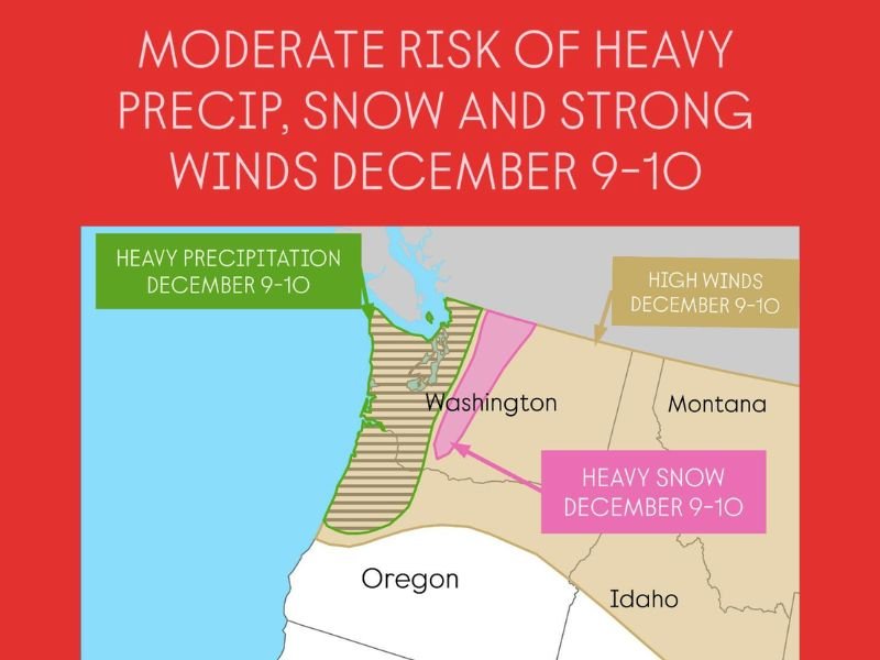
Meteorologists have placed the region under a moderate risk for heavy precipitation and wind, with potential for coastal flooding, erosion, and difficult travel conditions in mountain areas.
Heavy Rainfall Expected Along the Coast
Forecasters expect heavy precipitation to arrive first along the Washington and Oregon coastlines late Sunday night, intensifying through Monday as a strong moisture plume moves inland. The system is being fueled by a concentrated flow of warm, moist air from the Pacific Ocean — the defining feature of an atmospheric river.
Rainfall totals could range from 2 to 4 inches along the coast, with higher amounts possible in upslope areas of the Olympic and Coastal Ranges. Localized flooding and ponding on roads are possible, particularly in low-lying and poor drainage areas.
“An atmospheric river event is likely to bring widespread heavy precipitation across western Washington and northwest Oregon early next week,” forecasters said. “Residents should be prepared for possible flooding and slick road conditions.”
Heavy Snow for the Cascades and Idaho Mountains
While the lowlands will see mainly rain, colder air at higher elevations will support heavy snow across the Cascade Range and parts of northern Idaho.
Snowfall totals could exceed 12 inches in the Cascades, with the mountain passes becoming hazardous for drivers. Blowing snow and gusty winds could reduce visibility, creating treacherous conditions for travelers through Snoqualmie Pass and Stevens Pass.
In Idaho, high-elevation regions near the Washington border are also expected to receive several inches of new snow.
Strong Winds Across the Interior Northwest
As the storm system deepens, strong wind gusts of 40–55 mph are forecast across eastern Washington, northern Oregon, and parts of western Montana. These winds may down trees and power lines, potentially causing isolated power outages.
The National Weather Service has indicated that high wind advisories could be issued as the system approaches, particularly for open valleys and ridge tops east of the Cascades.
Coastal Flooding and Erosion Concerns
Along the Pacific shoreline, forecasters warn that coastal flooding and erosion could occur due to strong onshore winds and high surf. The combination of elevated tides and storm surge could produce minor flooding in vulnerable coastal communities.
Residents near Grays Harbor, Long Beach, and Tillamook are advised to monitor official updates and secure outdoor items before the storm’s arrival.
Outlook: System Clears by Midweek
Conditions are expected to gradually improve late Tuesday into Wednesday as the storm system weakens and moves inland. However, colder air behind the front could allow for lingering snow showers in the mountains and a continued chill across the region through midweek.
Residents are urged to stay alert for updated forecasts, potential weather advisories, and changing travel conditions as the system approaches.
For real-time updates on Pacific Northwest weather and safety alerts, visit NapervilleLocal.com.

I’ve lived in Naperville long enough to see how quickly our community changes — from new developments downtown to sudden shifts in our Midwest weather. Reporting on Naperville news and daily forecasts gives me the chance to keep neighbors informed about what really matters. My goal is simple: deliver clear, timely updates so you always know what’s happening in our city and what to expect from the skies above.