
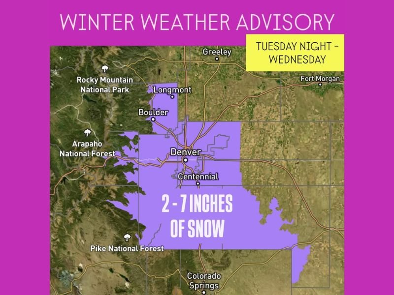
Denver, Colorado Braces for 2–7 Inches of Snow as Major Winter Storm Moves In Tuesday Night to Wednesday
DENVER, COLORADO — The biggest snowfall of the season is set to blanket the Denver Metro area beginning Tuesday night through Wednesday, with 2 to 7 inches of snow expected, according to a Winter Weather Advisory issued for central Colorado.
Forecasters say this incoming storm could bring the most significant snow totals so far this winter, especially for residents in the southern foothills and along the Palmer Divide, where localized totals may exceed 6 inches.
Heaviest Snow Expected Overnight into Wednesday
The snow is expected to begin late Tuesday evening and continue into Wednesday morning, impacting morning commutes across Denver, Boulder, and Centennial. The National Weather Service reports that heavier snow bands will develop overnight as colder air settles into the region.
Temperatures are expected to drop below freezing, allowing for steady accumulation on both grassy surfaces and roadways. Drivers are urged to prepare for slick roads, reduced visibility, and slower travel times during the Wednesday morning rush hour.
“This will likely be the most impactful snow event of the season for Denver so far,” forecasters said. “Heavier accumulations are expected south and west of the city, particularly in the foothills and Palmer Divide region.”
Snowfall Breakdown
- Denver Metro Area: 2–5 inches
- Southern Foothills & Palmer Divide: 5–7 inches
- Boulder & Longmont: 3–6 inches
- Colorado Springs area: Light accumulations possible north of the city
The Rocky Mountain and Arapaho National Forest areas may also see locally higher totals due to upslope flow, where mountain terrain enhances snowfall.
Travel Impacts and Safety Precautions
Travel conditions are expected to deteriorate quickly after sunset Tuesday, especially on Interstates 25 and 70. The Colorado Department of Transportation (CDOT) advises motorists to avoid unnecessary travel late Tuesday and early Wednesday if possible.
Residents are encouraged to have winter gear, ice scrapers, and emergency kits in their vehicles and to allow extra time for morning commutes.
Outlook Beyond Wednesday
The snow is expected to taper off by Wednesday afternoon, leaving behind colder air with daytime highs in the upper 20s to low 30s. Sunshine may return Thursday, but temperatures will remain below seasonal averages through the end of the week.
Another potential weather system could approach the Front Range over the weekend, though forecasters say it’s too early to determine if it will bring additional snow.
Residents in Denver, Boulder, and surrounding foothill communities should prepare now for significant snowfall and hazardous travel conditions through Wednesday morning.
Stay tuned for live weather updates and advisories at NapervilleLocal.com.

I’ve lived in Naperville long enough to see how quickly our community changes — from new developments downtown to sudden shifts in our Midwest weather. Reporting on Naperville news and daily forecasts gives me the chance to keep neighbors informed about what really matters. My goal is simple: deliver clear, timely updates so you always know what’s happening in our city and what to expect from the skies above.