
Colorado Snowstorm to Bring Up to 10 Inches Along I-25 Corridor From Denver to Colorado Springs Through Wednesday
COLORADO — A powerful winter storm is taking aim at the Colorado Front Range, with heavy snowfall expected from Tuesday night through Wednesday across much of the I-25 corridor, including Denver, Boulder, Colorado Springs, and Castle Rock. Meteorologists say the system could dump between 4 and 10 inches of snow, leading to dangerous road conditions during both the morning and evening commutes.
The latest First Alert Weather models show the heaviest snow bands developing between 3 a.m. and 11 a.m. Wednesday, with snowfall rates potentially reaching 1 inch per hour at times. Commuters in the Denver metro area are urged to expect messy travel, reduced visibility, and slick roads.
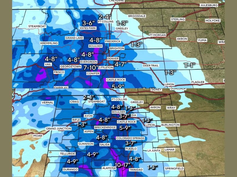
Snow Totals and Impacted Areas
According to the updated snowfall forecast:
- Denver and Littleton: 4–7 inches
- Castle Rock: 5–9 inches
- Boulder and Evergreen: 4–8 inches
- Colorado Springs: 3–7 inches
- Alamosa and Trinidad: 10–17 inches (highest totals in southern Colorado)
- Vail and Telluride: 4–9 inches
- Fort Collins and Greeley: 1–3 inches
The I-25 corridor from Fort Collins to Pueblo is expected to bear the brunt of the storm, with travel conditions deteriorating quickly overnight. Snow will continue through midday Wednesday before tapering off in the evening.
Morning Commute Could Be Treacherous
Forecasters warn that both morning and evening commutes will be heavily affected. Plummeting temperatures will make road surfaces icy, especially in areas that receive over 6 inches of snow. Municipal crews are preparing to deploy plows and salt trucks overnight to manage accumulation before rush hour.
“This is a high-impact storm with snowfall ramping up before dawn and lasting through the day,” meteorologists said. “Drivers should plan for major slowdowns and give themselves extra travel time.”
Southern Mountains to See Heaviest Totals
The San Luis Valley and southern mountain regions, including Alamosa, Durango, and Telluride, could see up to a foot of snow in some locations. These higher elevations are likely to experience blowing snow and near whiteout conditions, particularly on mountain passes like Wolf Creek and Monarch.
Safety and Travel Tips
Authorities urge drivers to:
- Avoid unnecessary travel during peak snowfall hours.
- Keep an emergency kit in vehicles, including blankets and food.
- Allow extra braking distance and lower speeds.
- Check for chain restrictions and road closures before travel.
Air travel may also experience delays at Denver International Airport (DIA) as snow bands move through Wednesday morning. Passengers are advised to monitor airline alerts for schedule changes.
Storm to Exit by Wednesday Evening
Snow is expected to taper off by late Wednesday evening as the storm shifts eastward. However, frigid temperatures will persist through Thursday morning, keeping untreated roads icy and dangerous.
Stay tuned to NapervilleLocal.com for continuing updates on this developing Colorado snowstorm.

I’ve lived in Naperville long enough to see how quickly our community changes — from new developments downtown to sudden shifts in our Midwest weather. Reporting on Naperville news and daily forecasts gives me the chance to keep neighbors informed about what really matters. My goal is simple: deliver clear, timely updates so you always know what’s happening in our city and what to expect from the skies above.