
Oklahoma City and Surrounding Areas Could See Increased Snowfall Thursday Morning as Models Show Uptrend in Accumulation
OKLAHOMA CITY, OKLAHOMA — Forecast confidence is growing for a winter weather uptrend across central Oklahoma, with new model guidance showing higher snow and sleet totals developing during the Thursday morning commute. Meteorologists are warning drivers in the Oklahoma City metro area and surrounding regions to brace for hazardous travel conditions similar to what the state experienced earlier this week.
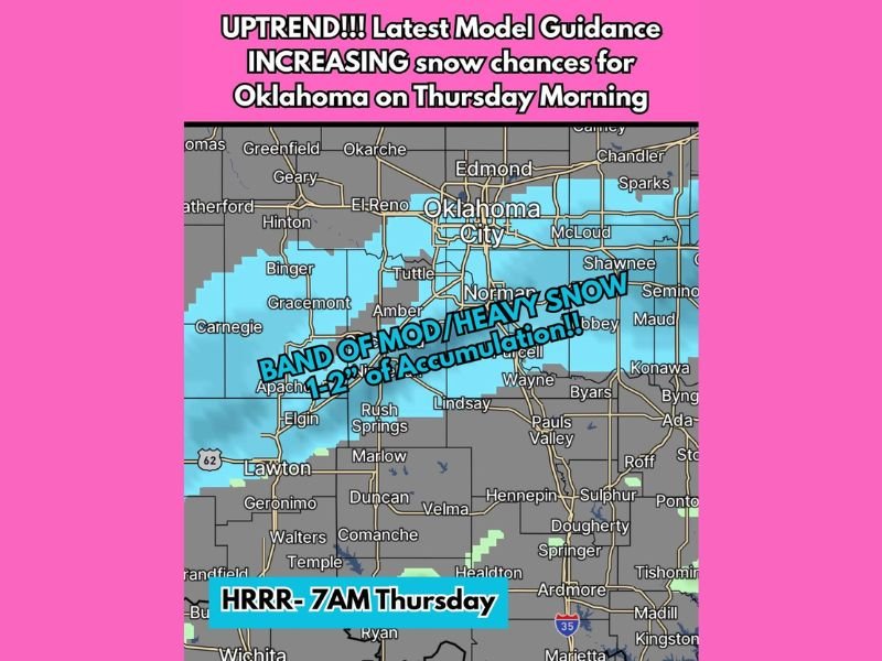
According to the latest short-range model updates, a band of moderate to heavy snow could set up across parts of Oklahoma County, Cleveland County, and Grady County, extending westward toward El Reno and Binger and south toward Lawton. Forecasters say the system may bring 1 to 2 inches of snow accumulation in isolated spots, particularly on the west and southwest sides of the Oklahoma City metro area.
Models Indicate a Stronger System
The updated HRRR (High-Resolution Rapid Refresh) model for 7 a.m. Thursday shows a more defined and moisture-rich band of snow stretching along the I-40 corridor. This trend marks an increase from previous model runs, which predicted lighter sleet and snow coverage.
Meteorologists emphasize that even small changes in temperature or timing could significantly impact road conditions. With precipitation expected to fall during the height of the morning rush hour, slick bridges, icy overpasses, and reduced visibility are likely to create travel difficulties across the region.
Areas Most Likely to See Accumulation
- Oklahoma City (West and South sides) – 1 to 2 inches possible
- Norman, Moore, and Tuttle – Light to moderate snow, potential for slick roads
- Lawton and Elgin – Trace to 1 inch of snow, localized heavier bursts possible
- El Reno and Gracemont – Periods of moderate snow accumulation
Officials advise residents to monitor local forecasts closely and plan for possible delays on major routes, including I-40, I-44, and I-35.
Morning Commute Concerns
Forecasters are drawing comparisons to Monday’s winter event, which caused widespread travel disruptions across the Oklahoma City metro area. Thursday’s system, while expected to be brief, could once again produce patches of ice and compacted snow on untreated surfaces.
Drivers should allow extra time for their commute, reduce speeds, and maintain greater following distances. Emergency management officials are urging caution, noting that even light accumulations can cause major problems when temperatures are near freezing.
What to Expect Next
Snow and sleet are expected to taper off by late Thursday morning, followed by gradual clearing in the afternoon. However, cold air will linger behind the system, keeping high temperatures in the upper 30s to low 40s through the day.
Meteorologists are continuing to track the storm closely, with additional model updates expected overnight. Residents should stay tuned for advisories or potential winter weather alerts from the National Weather Service in Norman.
Stay updated with real-time weather coverage and community reports at NapervilleLocal.com.

I’ve lived in Naperville long enough to see how quickly our community changes — from new developments downtown to sudden shifts in our Midwest weather. Reporting on Naperville news and daily forecasts gives me the chance to keep neighbors informed about what really matters. My goal is simple: deliver clear, timely updates so you always know what’s happening in our city and what to expect from the skies above.