
Midwest and Great Lakes Brace for Multiple Alberta Clipper Systems Bringing Fast-Moving Snow Bursts Next Week
ILLINOIS — A dynamic and active weather pattern is setting up across the Midwest and Great Lakes beginning this weekend, as forecasters warn of a “clipper parade” — multiple fast-moving storm systems dropping out of Canada that will bring bursts of snow, gusty winds, and sharp temperature drops from December 5 through December 12.
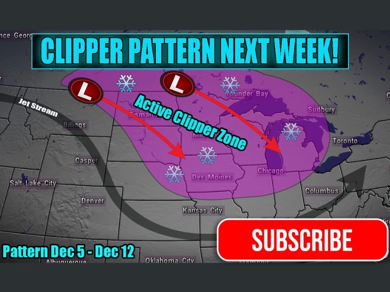
According to meteorologist Adam Lucio, the latest forecast models show the jet stream aligning in a way that will favor a continuous flow of Alberta Clipper systems moving southeast out of Canada into the northern Plains, upper Midwest, and Great Lakes region. These compact but energetic systems typically bring brief, intense snowfall, followed by bitter cold air and strong northwest winds.
Active Clipper Zone to Impact Chicago, Minneapolis, and Detroit
The active clipper zone, highlighted on forecast maps, stretches from the northern Rockies through the Dakotas, Iowa, and into Illinois, Wisconsin, and Michigan. Areas including Chicago, Des Moines, Minneapolis, and Detroit are all in the path of potential snow bursts through the week ahead.
Each clipper is expected to move through rapidly — often lasting just 12 to 24 hours — but multiple systems in succession could accumulate several inches of snow overall, especially where bands overlap or snow squalls develop.
Meteorologists caution that travel impacts could occur frequently through the upcoming week, even if individual snow events remain light to moderate. Short bursts of snow with reduced visibility, slick roads, and wind gusts topping 30 to 40 mph are possible with stronger systems.
Pattern Details: December 5–12
The forecasted pattern, active between December 5 and December 12, will be driven by a northwest jet stream flow diving out of Alberta, Canada. The alignment allows clippers to ride along this jet stream “track,” drawing limited moisture but tapping into enough cold energy to produce fast-moving snow systems.
While these storms rarely bring heavy accumulations, they are notorious for their timing and intensity, often catching commuters off guard during short-lived but impactful bursts of snow.
Lucio notes that the jet streak energy could enhance some of the clippers, leading to localized snow squalls — brief but intense snow showers that can quickly reduce visibility and cause whiteout conditions on highways.
What to Expect for Illinois and the Midwest
Residents across Illinois, Iowa, Wisconsin, and Michigan should expect:
- Multiple rounds of snow showers through the week, generally light but frequent.
- Occasional bursts of heavier snow, particularly during morning or evening commutes.
- Gusty winds and falling temperatures following each system.
- Wind chills dropping into the teens or single digits behind stronger clippers.
Meteorologists are advising motorists to prepare for rapidly changing conditions, especially on interstates such as I-80, I-90, and I-94, where visibility could deteriorate quickly during snow squalls.
Cold Air Follows Each System
Following each clipper, Arctic air will sweep south, keeping temperatures below average across much of the central U.S. through mid-December. Daytime highs across northern Illinois and southern Wisconsin are expected to remain in the upper 20s to mid-30s, with overnight lows dipping into the teens.
By next weekend, the persistent northwest flow may also open the door for lake-effect snow to develop downwind of Lake Michigan and Lake Superior, adding to regional totals.
Outlook
While no single storm currently appears major, the repeated pattern of snow bursts and cold air could make next week feel like the first true stretch of winter for much of the Midwest.
Forecasters emphasize that this pattern “will remain active,” meaning additional clippers could continue beyond December 12 if the jet stream remains locked in its current position.
Stay informed on local forecasts and road conditions as the clipper systems begin to move through. For ongoing Midwest weather coverage, visit NapervilleLocal.com.

I’ve lived in Naperville long enough to see how quickly our community changes — from new developments downtown to sudden shifts in our Midwest weather. Reporting on Naperville news and daily forecasts gives me the chance to keep neighbors informed about what really matters. My goal is simple: deliver clear, timely updates so you always know what’s happening in our city and what to expect from the skies above.