
Oklahoma Winter Weather Advisory: Freezing Drizzle, Sleet, and Snow to Create Hazardous Travel Conditions Early Thursday
TULSA, OKLAHOMA — A Winter Weather Advisory is now in effect for multiple counties across central and northeast Oklahoma as a wintry mix of freezing drizzle, sleet, and light snow moves through the region overnight into Thursday morning.
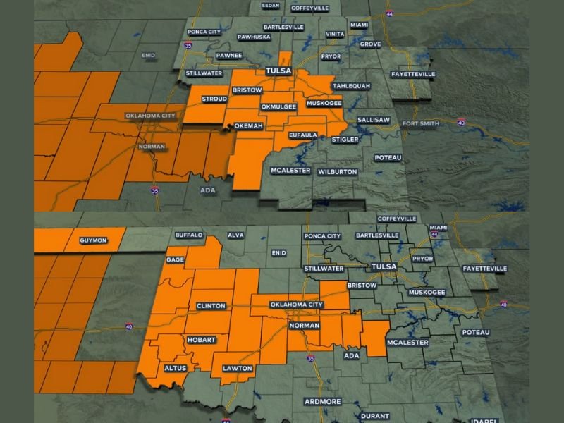
The advisory, issued by the National Weather Service, covers the Tulsa metro area and nearby counties including Creek, Okfuskee, Okmulgee, Wagoner, Muskogee, and McIntosh, remaining active from 3 a.m. to 3 p.m. Thursday. Additional counties to the west and south of Tulsa — including Oklahoma City, Norman, and Lawton — are also under winter weather alerts through mid-afternoon.
Forecasters warn that hazardous road conditions are expected, particularly during the Thursday morning commute, as temperatures drop below freezing and precipitation begins to accumulate.
Freezing Drizzle, Sleet, and Snow to Develop Overnight
Meteorologists say the first impacts will begin after midnight, as temperatures dip below 32°F, leading to pockets of freezing drizzle across southern Kansas and northeastern Oklahoma. Between 3 a.m. and 5 a.m., conditions will deteriorate further with sleet pellets and light snow mixing into the drizzle.
By early morning, a narrow band of snow and sleet is expected to develop across western and central Oklahoma, gradually expanding eastward through the Tulsa area. Accumulations of 1 to 2 inches of snow are possible in localized spots, with lighter coatings of sleet and ice elsewhere.
“This will be a messy setup — a narrow but intense band of mixed precipitation,” forecasters explained. “Even small amounts of freezing rain or sleet can make roads extremely slick, particularly during the morning rush.”
Counties Under Winter Alerts
According to News On 6 Weather and the NWS office in Norman, the following regions are under active advisories until 3 p.m. Thursday:
- Northeast Oklahoma: Tulsa, Creek, Okfuskee, Okmulgee, Wagoner, Muskogee, and McIntosh counties
- Central and Western Oklahoma: Oklahoma, Canadian, Caddo, Grady, Cleveland, Comanche, and Jackson counties
Additional advisories may be added overnight as the system spreads eastward.
Travel Impacts and Safety Warnings
Road crews are on standby across the affected counties, but conditions could deteriorate rapidly during the early hours of Thursday. Commuters are advised to avoid unnecessary travel before sunrise and to allow extra time if driving is unavoidable.
Key impacts include:
- Slick bridges and overpasses during the morning commute
- Reduced visibility from freezing drizzle and light snow
- Localized icy spots through midday, especially along I-44 and I-40 corridors
- Wind chills in the upper teens to low 20s, making conditions feel even colder
“Drivers should exercise extreme caution — it doesn’t take much freezing drizzle to create hazardous black ice,” officials warned.
Cold and Blustery Afternoon Ahead
North winds will strengthen behind the system Thursday afternoon, producing gusts near 25 mph and keeping highs in the mid-30s. The wintry mix is expected to taper off by early evening, with gradual improvement in road conditions overnight.
Residents are encouraged to stay alert to updated advisories and radar trends as the situation evolves. Another round of light snow could move through parts of Oklahoma late in the weekend, depending on upper-air patterns.
For continued updates and travel safety information, visit NapervilleLocal.com.

I’ve lived in Naperville long enough to see how quickly our community changes — from new developments downtown to sudden shifts in our Midwest weather. Reporting on Naperville news and daily forecasts gives me the chance to keep neighbors informed about what really matters. My goal is simple: deliver clear, timely updates so you always know what’s happening in our city and what to expect from the skies above.