
Virginia and North Carolina Brace for Friday Morning Snow and Wintry Mix Along I-95 Corridor
RICHMOND, VIRGINIA — A winter weather system is on track to bring snow, sleet, and rain to portions of Virginia and North Carolina early Friday morning, with accumulating snowfall likely from the Blue Ridge Mountains eastward to the Richmond area.
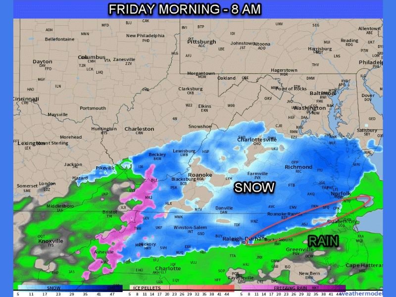
Simulated radar models for 8 a.m. Friday show widespread snow stretching from Roanoke and Charlottesville through Richmond, with a mixing zone of sleet and freezing rain farther south toward Raleigh and Norfolk. The storm is expected to impact the Friday morning commute, particularly along the I-95 corridor.
Snow Expected Across Central Virginia and Southern Appalachians
According to meteorologists, the best chances for steady snow accumulation will occur from the Peninsula westward, extending inland through Southside Virginia and central North Carolina. Areas north of the James River and west toward Charlottesville and Roanoke are forecast to see the most consistent snowfall.
Preliminary snowfall estimates include:
- Richmond and I-95 corridor: 1 to 3 inches of snow possible
- Roanoke, Farmville, and Lynchburg: 2 to 4 inches
- Charlottesville and Blue Ridge foothills: 3 to 5 inches, locally higher in higher elevations
- Raleigh-Durham to Danville: light snow and sleet mix, less than 1 inch expected
Meteorologists note that the mixing zone—roughly from Raleigh, NC, to Norfolk, VA—will likely experience a transition between snow and freezing rain, depending on surface temperatures and timing of the cold air.
Early Morning Impacts and Travel Conditions
The storm is expected to move in overnight, with snow beginning before dawn Friday across western and central Virginia. By 6–8 a.m., snow and sleet will overspread the region, reducing visibility and coating roadways just as the morning rush begins.
Travelers along I-64, I-81, and I-95 should be prepared for slick roads and potential delays, especially in untreated areas.
Transportation officials in both states are urging drivers to:
- Allow extra travel time and reduce speeds
- Avoid unnecessary trips during peak snowfall
- Watch for icy patches on bridges and overpasses
Road conditions are expected to improve by midday Friday as precipitation tapers off and temperatures rise slightly above freezing in southern areas.
Rain to the South, Wintry Mix Along the Coast
Farther south, eastern North Carolina and the Virginia coast will see mostly rain with some brief periods of freezing drizzle early on. The transition line between snow and rain is forecast to fluctuate throughout the morning, particularly along Greenville, Norfolk, and the Outer Banks.
While this region is not expected to see significant accumulation, wet conditions could still lead to reduced traction and low visibility in heavier rain bands.
Forecast Outlook
By Friday afternoon, precipitation will shift northeast and weaken, leaving behind lingering snow showers in the mountains and dry but cold conditions for the weekend. Temperatures will remain in the 30s and low 40s through Saturday before a gradual warm-up early next week.
Meteorologists are closely watching the next potential storm system that could arrive by mid-next week, possibly bringing another round of wintry precipitation to the Mid-Atlantic.
Stay up to date on local conditions, advisories, and radar updates at NapervilleLocal.com.

I’ve lived in Naperville long enough to see how quickly our community changes — from new developments downtown to sudden shifts in our Midwest weather. Reporting on Naperville news and daily forecasts gives me the chance to keep neighbors informed about what really matters. My goal is simple: deliver clear, timely updates so you always know what’s happening in our city and what to expect from the skies above.