
Brutal Arctic Blast to Send Temperatures Plummeting Across Iowa and Midwest — Up to 40°F Below Normal With Dangerous Wind Chills
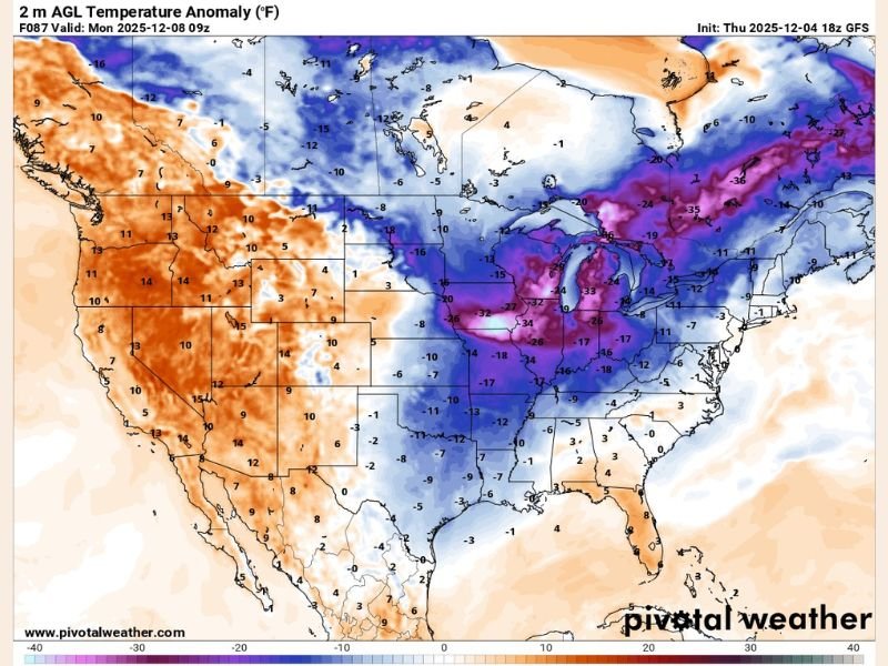
DES MOINES, IOWA — A record-shattering Arctic outbreak is set to grip the Midwest starting Sunday night into Monday, sending temperatures across Iowa, Illinois, Wisconsin, and Minnesota plummeting as much as 40°F below normal for early December.
According to GFS weather model data, the incoming Arctic front will unleash some of the coldest air of the season so far, with wind chills dropping as low as –20°F at times, making outdoor exposure dangerous for extended periods.
Record Cold Expected Across the Upper Midwest
Meteorologists warn that this event could break long-standing temperature records across the region, with daytime highs struggling to reach single digits and overnight lows falling well below zero.
In Iowa, where the core of the Arctic air will settle early Monday, wind chills will feel between –15°F and –25°F, especially across northern and central counties. Cities including Des Moines, Cedar Rapids, and Waterloo are forecast to see bitter cold reinforced by strong northwest winds.
The National Weather Service cautioned that frostbite could occur on exposed skin in as little as 15–30 minutes, urging residents to limit outdoor activity and dress in layers.
“This is the kind of cold that gets dangerous quickly,” said meteorologist Katie Murphy of NWS Des Moines. “Wind chills this extreme can be life-threatening if you’re not properly prepared.”
Widespread Impacts Across the Midwest
The Arctic blast won’t be limited to Iowa — its reach will extend across much of the Midwest and Great Lakes region, including:
- Illinois and Wisconsin: Temperatures 30–35°F below normal, with lows near –10°F in some rural areas.
- Minnesota: Wind chills between –25°F and –35°F expected, especially in northern portions.
- Michigan and Indiana: Rapid temperature drops could cause icy road conditions and black ice hazards.
In Chicago, forecasters predict temperatures to hover in the low teens Monday morning with wind chills around –10°F, marking one of the city’s coldest December starts in recent years.
What’s Behind the Arctic Outbreak
The cold surge is being driven by a powerful Arctic high-pressure system diving south from Canada, displacing milder air and creating a sharp temperature contrast across the central U.S.
This setup allows frigid polar air to spill deep into the Plains and Midwest, aided by a strong jet stream pattern that continues to funnel cold air masses southward. Meteorologists note that such intense temperature drops are unusual this early in December, even for northern states accustomed to winter chill.
Precautions and Travel Advisories
Officials across the Midwest are warning residents to take precautions as temperatures fall rapidly Sunday night:
- Limit time outdoors. Wind chills near –20°F can cause frostbite in less than 30 minutes.
- Keep emergency kits in vehicles, including blankets, flashlights, and food in case of breakdowns.
- Protect pipes and pets. Prolonged cold could lead to freezing and damage.
- Check on vulnerable neighbors and elderly individuals.
Drivers are also urged to exercise caution as the sudden temperature plunge may create icy spots and flash freeze conditions on highways, particularly overnight.
Outlook: Cold Lingers Through Midweek
The bitter cold is expected to persist through Wednesday, with gradual moderation by late week. However, long-range forecasts suggest another reinforcing shot of Arctic air could arrive by mid-December, keeping much of the central U.S. locked in a colder-than-average pattern.
Meteorologists say this stretch of weather will mark one of the most extreme early-December cold snaps in recent years, rivaling outbreaks seen in 2013 and 2019.
Residents are urged to stay informed through local forecasts and follow safety advisories as conditions evolve.
Stay up to date with severe weather and safety alerts at NapervilleLocal.com.

I’ve lived in Naperville long enough to see how quickly our community changes — from new developments downtown to sudden shifts in our Midwest weather. Reporting on Naperville news and daily forecasts gives me the chance to keep neighbors informed about what really matters. My goal is simple: deliver clear, timely updates so you always know what’s happening in our city and what to expect from the skies above.