
Arctic Blast to Send North Texas Temperatures Into the 20s Early Monday Before Rapid Midweek Warm-Up
DALLAS–FORT WORTH, TEXAS — North Texas residents should prepare for a sharp drop in temperatures early Monday morning as an Arctic air mass surges southward, pushing lows into the mid to upper 20s across much of the Dallas–Fort Worth area. The cold blast follows a brisk, windy Sunday that will make conditions feel even colder than the thermometer reads.
Cold Front Timing and Sunday Conditions
The front is expected to sweep through Saturday night, bringing a noticeable chill to the region by sunrise Sunday. Afternoon highs will only reach the low to mid-50s, though northwest winds gusting up to 35 mph will make it feel more like the 40s.
Despite the blustery feel, skies will remain mostly sunny, helping to prevent any precipitation. By Sunday night, winds will begin to ease as the core of the cold air settles over North Texas.
“This is a classic December front — dry, breezy, and sharp,” meteorologist Mike Boylan of Spaghetti Models said. “Once it moves through, temperatures will drop fast, especially overnight into Monday morning.”
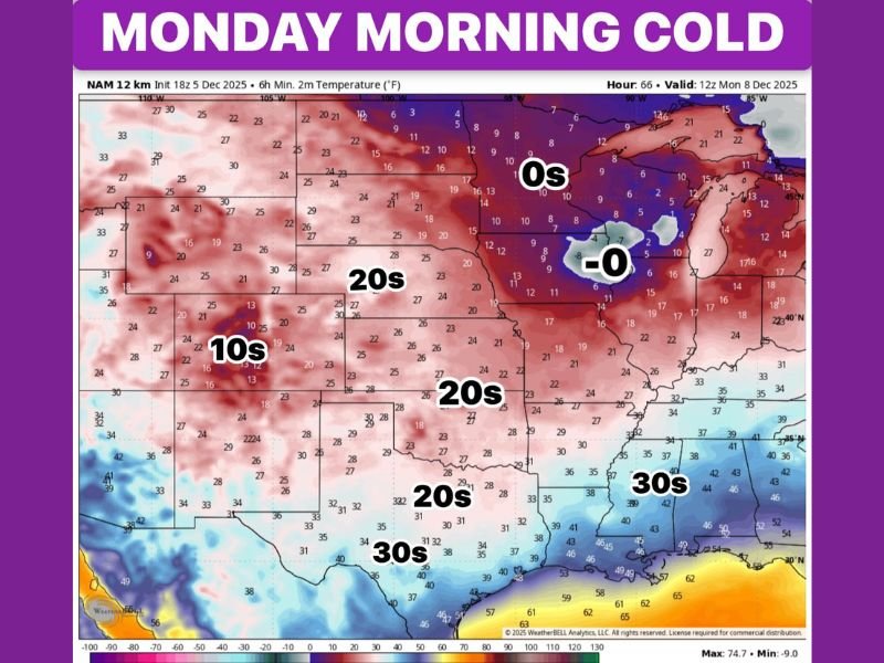
Monday Morning Freeze Expected
By early Monday, widespread temperatures in the 20s are expected across North and Central Texas, according to the latest model guidance. Areas near major airports, such as DFW International and Love Field, may stay just above freezing, but rural and northern suburbs are likely to fall into the mid-20s.
Wind chills will make it feel even colder during the early morning commute.
- Dallas / Fort Worth: Lows near 28°F; wind chills in the low 20s.
- Denton / Gainesville: Lows 24–26°F.
- Waco: Around 30°F.
- Abilene: Mid-20s.
By Monday afternoon, sunny skies will return, allowing temperatures to recover to around 50°F, offering a brief break before a milder air mass moves in.
Quick Warm-Up Follows the Chill
The cold snap will be short-lived. Forecast models show a significant warm-up beginning Tuesday, with highs rebounding into the mid-60s, and possibly the 70s by midweek.
This pattern of rapid swings — from Arctic chill to spring-like warmth — is typical for Texas in December, meteorologists say, driven by fluctuating jet stream patterns.
“Texans will go from heavy jackets to short sleeves in about 48 hours,” Boylan added. “That’s winter in the Lone Star State.”
What Residents Should Know
- Freeze precautions: Protect plants and pets Sunday night into Monday morning.
- Sunny skies: No rain expected through early next week.
- Rapid rebound: Temperatures climb sharply beginning Tuesday.
By midweek, North Texas is expected to see highs near 70°F, marking a dramatic turnaround from the frigid start of the week.
For now, residents should brace for a frosty Monday morning before the warmth of late-week sunshine returns.
Stay updated with verified regional forecasts and temperature alerts at NapervilleLocal.com.

I’ve lived in Naperville long enough to see how quickly our community changes — from new developments downtown to sudden shifts in our Midwest weather. Reporting on Naperville news and daily forecasts gives me the chance to keep neighbors informed about what really matters. My goal is simple: deliver clear, timely updates so you always know what’s happening in our city and what to expect from the skies above.