
Iowa and Surrounding Midwest States Brace for Fast-Moving Clipper System Bringing Up to 8 Inches of Snow and Hazardous Travel Saturday
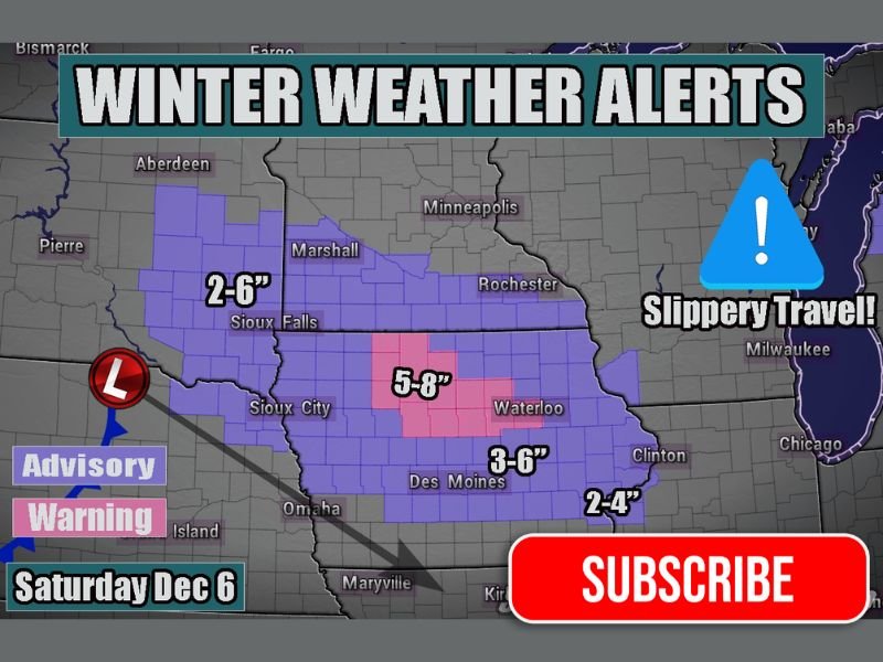
IOWA, UNITED STATES — A fast-moving clipper system is set to sweep across Iowa and surrounding Midwest states on Saturday, December 6, bringing a burst of snow, gusty winds, and dangerous travel conditions. According to early forecasts, areas across central and northern Iowa could see 5 to 8 inches of accumulation, while surrounding regions like South Dakota, Minnesota, and northern Illinois may pick up 2 to 6 inches.
Clipper to Deliver Quick but Intense Snowfall
Meteorologists describe this system as a “classic Alberta clipper,” a compact but powerful storm that moves rapidly across the northern Plains and upper Midwest. These systems are known for short bursts of heavy snow, often accompanied by strong winds that can quickly reduce visibility on highways. Forecasters warn that even though total snowfall amounts will not be extreme, the fast onset and intensity will make travel conditions especially treacherous for motorists.
Winter Weather Advisories and Warnings have been issued across Iowa, Minnesota, and eastern South Dakota. The heaviest band of snow is expected from Sioux City to Des Moines, where accumulation could approach 8 inches in localized areas. Farther east toward Waterloo and Clinton, totals are expected to range from 2 to 6 inches, enough to cause slick roads and limited visibility.
Travel and Safety Concerns Across the Region
The snow will move in quickly Saturday morning and continue into the evening, tapering off by late night. Drivers are urged to avoid unnecessary travel during the storm’s peak hours, as road conditions will deteriorate rapidly. Meteorologists emphasize that “slippery travel” will be the main hazard, even where snow totals are lower, because light, powdery snow will blow easily and cause drifting.
Local transportation departments are preparing to pre-treat major highways and respond with plows as snowfall rates increase. Motorists should expect reduced visibility and icy stretches, particularly on rural roads and overpasses. Forecasters also remind travelers that temperatures behind the clipper will plunge into the teens and single digits, allowing any melted snow to quickly refreeze overnight.
Wider Midwest Impact
While Iowa will bear the brunt of the system, neighboring states will also feel its effects. South Dakota and southern Minnesota will see 2 to 6 inches, while parts of northern Illinois and Wisconsin could receive 1 to 3 inches. The snow will move fast but may create ripple effects for air travel across major Midwest hubs including Chicago O’Hare and Minneapolis-St. Paul International Airport.
For Naperville and northern Illinois, light snow and gusty winds are possible late Saturday into Sunday morning. Though accumulation is expected to remain minimal, the quick drop in temperatures may lead to icy spots on untreated surfaces.
Preparation and Final Outlook
Experts recommend travelers keep emergency kits, blankets, and extra fuel in vehicles throughout the weekend. Those driving long distances across the Midwest should monitor local advisories and be ready for sudden visibility drops during the heaviest snow bands.
The National Weather Service continues to monitor the clipper’s speed and track, with the potential for adjustments in warning zones as the system approaches. Even a slight shift in its path could change where the heaviest snow falls.
Residents across the region are urged to stay tuned to local forecasts and road updates before heading out. For more weather alerts, regional forecasts, and safety information, visit NapervilleLocal.com for continuous updates.

I’ve lived in Naperville long enough to see how quickly our community changes — from new developments downtown to sudden shifts in our Midwest weather. Reporting on Naperville news and daily forecasts gives me the chance to keep neighbors informed about what really matters. My goal is simple: deliver clear, timely updates so you always know what’s happening in our city and what to expect from the skies above.