
Alaska Braces for Severe Arctic Outbreak Bringing Blizzard Conditions, 80 MPH Winds, and Wind Chills Down to 60 Below Zero
ANCHORAGE, ALASKA — A powerful Arctic outbreak is set to grip much of Alaska this weekend, unleashing a dangerous combination of blizzard conditions, heavy snow, and life-threatening cold that could persist into early next week. Forecasters are warning residents across the state to prepare for wind chills as low as 60°F below zero, along with winds up to 80 mph in some areas.
Extreme Cold and Winds to Dominate Interior Alaska
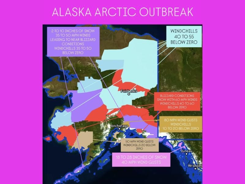
The National Weather Service reports that central and interior parts of Alaska — including Fairbanks and the Yukon Flats region — will face the most severe cold. Wind chills are forecast to drop between 40°F and 55°F below zero, driven by sustained winds of 35 to 50 mph. These conditions could lead to near-blizzard visibility, particularly in areas expecting 2 to 10 inches of snow through Monday.
Meteorologists describe this outbreak as one of the most intense Arctic air events of the season, warning that frostbite can occur on exposed skin in under 10 minutes. The combination of blowing snow and extreme cold will make travel treacherous or impossible across many parts of Alaska’s interior.
Blizzard Warnings for Coastal and Western Alaska
Blizzard warnings are in effect across western and southwestern Alaska, where winds may reach 60 mph and whiteout conditions are expected. In these regions, including the Seward Peninsula and lower Yukon Valley, snow will combine with high winds to create blinding visibility and drifting snow through early Monday. Wind chills in these zones could plunge between 40°F and 60°F below zero, making any outdoor activity extremely dangerous.
Along Alaska’s southern coast, near Anchorage and the Kenai Peninsula, forecasters expect gusts up to 50 mph with wind chills near 20°F below zero. The heavy snowfall zone near the Gulf of Alaska could see 18 to 28 inches of accumulation, accompanied by 40 mph wind gusts. These conditions will severely impact marine operations, aviation routes, and mountain passes.
Southeast Alaska and Juneau Region to See Heavy Snow
In southeastern Alaska, including Juneau and Wrangell, snowfall totals could reach one to two feet through Sunday night. Winds gusting to 40 mph will cause additional blowing and drifting snow, further complicating travel along coastal highways and airport approaches.
The Alaska Department of Transportation has warned that several roadways may become impassable or closed during the height of the storm, particularly in mountain corridors. Ferry and air services across southeast Alaska are also expected to face significant delays.
Dangerous Cold and Long-Lasting Impacts
Forecasters caution that this Arctic outbreak won’t be short-lived. Temperatures across much of Alaska will remain well below zero into early next week, prolonging dangerous cold and straining heating systems. Residents are urged to check heating fuel supplies, secure emergency kits, and limit outdoor exposure during the coldest periods.
Authorities also emphasize the importance of checking on elderly neighbors, pets, and livestock, as prolonged exposure could be deadly. Frostbite, hypothermia, and mechanical failures from extreme cold are all major concerns.
The National Weather Service in Fairbanks describes the event as “a multi-day Arctic crisis for the region,” with impacts that could extend into the middle of next week before temperatures slowly begin to moderate.
For continuous updates on this Arctic outbreak, including blizzard alerts and safety guidance across Alaska, visit NapervilleLocal.com for the latest coverage.

I’ve lived in Naperville long enough to see how quickly our community changes — from new developments downtown to sudden shifts in our Midwest weather. Reporting on Naperville news and daily forecasts gives me the chance to keep neighbors informed about what really matters. My goal is simple: deliver clear, timely updates so you always know what’s happening in our city and what to expect from the skies above.