
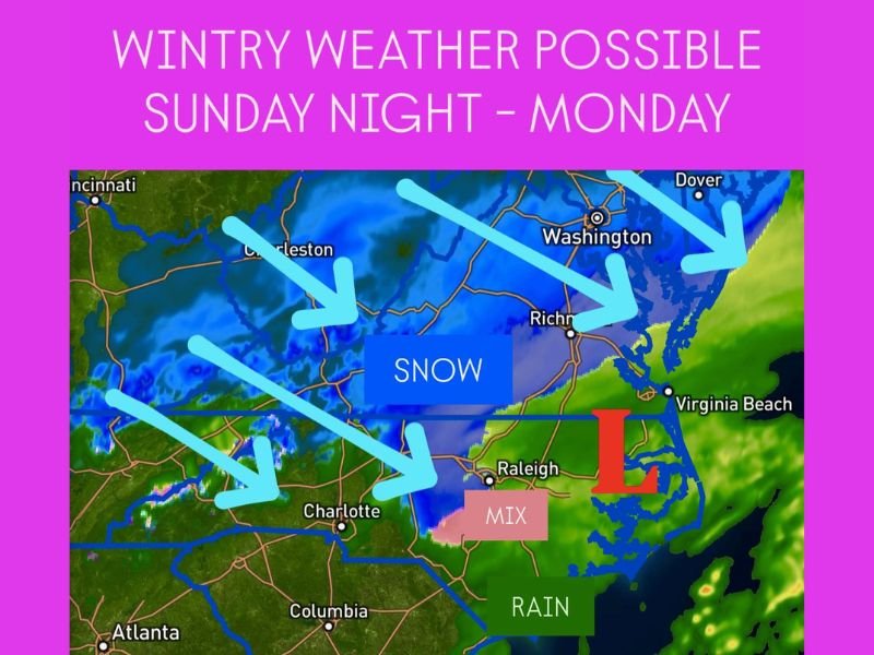
Virginia, North Carolina, Tennessee, and West Virginia to See Snow, Sleet, and Rain Sunday Night Into Monday as Winter System Moves Across Mid-Atlantic
RICHMOND, VIRGINIA — A developing winter storm system is forecast to move through Virginia, North Carolina, Tennessee, and West Virginia beginning Sunday night into Monday, bringing a mix of snow, sleet, and rain to much of the Mid-Atlantic. The system will create slippery travel conditions, with several inches of snow possible in the Appalachian Mountains and lighter accumulations expected in lower elevations.
Snow and Mixed Precipitation to Develop Overnight
Meteorologists say precipitation will begin late Sunday evening as a surge of moisture from the Gulf meets cold Arctic air across the Appalachians. This combination will produce snow and wintry mix across western Virginia, eastern Tennessee, and northern North Carolina, continuing into early Monday morning.
The highest snow totals are expected along the Tennessee–North Carolina border and the mountain regions of Virginia and West Virginia, where 2 to 4 inches of snow could accumulate, with isolated areas reaching 5 inches. Lower elevations in central Virginia and the Piedmont region of North Carolina may see a brief mix of sleet and freezing rain before transitioning to lighter snow by Monday morning.
Travel Impacts Across the Region
The National Weather Service warns that roads could quickly become slick and hazardous overnight Sunday through the Monday morning commute. Drivers across Roanoke, Asheville, and Charleston should use extra caution, as black ice and snow-covered roads could lead to accidents and delays.
Major routes such as I-81, I-64, and I-40 are expected to experience reduced visibility and icy patches, particularly in elevated areas. Even minor accumulations could cause travel disruptions across Charlotte, Raleigh, and Richmond, where drivers are less accustomed to winter conditions.
As the storm tracks northeast Monday afternoon, Washington, D.C., and Baltimore may see a brief window of light snow before precipitation tapers off by evening. While accumulations there will be minimal, gusty winds and wet roads could still make travel challenging during the evening commute.
Cold Air to Follow the System
Once the storm exits late Monday, a mass of cold, dry air will settle over the region, keeping temperatures 10 to 15 degrees below normal into early Tuesday. The lingering cold will allow for slick roads to persist overnight, especially in shaded and untreated areas.
Forecasters are also watching another potential clipper system later in the week that could bring a quick burst of snow across portions of the Mid-Atlantic and Appalachians by midweek.
Residents in affected states are urged to monitor weather updates and prepare for changing road conditions overnight. Those in mountain communities should remain alert for rapid freezing and ice development, especially before sunrise Monday.
For continuous coverage, travel alerts, and regional forecasts, visit NapervilleLocal.com for the latest weather updates.

I’ve lived in Naperville long enough to see how quickly our community changes — from new developments downtown to sudden shifts in our Midwest weather. Reporting on Naperville news and daily forecasts gives me the chance to keep neighbors informed about what really matters. My goal is simple: deliver clear, timely updates so you always know what’s happening in our city and what to expect from the skies above.